.jpg)
Ohio River
Twelve Pole Creek
(Mile 313.5) to Symmes Creek/Huntington, WV (Mile 308.5)
Tuesday, September 11, 2012
(Navigation Charts 146 and 147)
Yes, this is an Ohio River Navigation story, yet the Twelve Pole Creek ended up
stealing the show today!
For
this section I put in at the
David Harris Riverfront Park
in downtown Huntington, West Virginia.
The park lies along the town's break wall which protects the city from
high water. Thus, when you look at the city from the water you see the
park, then the break wall, and then the downtown area lying just behind it.
This is a nice put-in is with plenty of parking, a restroom and even a
marina (no longer here). More on Huntington later, but today I got on the
water and headed on downriver to Twelve Pole Creek.
You'll find that Twelve Pole
enters the Ohio at mile 313.5, directly across from the community of Burlington,
Ohio. There's plenty going on here. As you'll note below there's apt
to be a very long line of barges along the shoreline as you look downriver. I
haven’t paddled down there yet, but I’m wondering
just how challenging it will be when I do. I’d wondered why I wasn’t
seeing more business related river traffic closer to Huntington and
the area above it. Well, it seems things are more concentrated down here!
There is a very large steel plant just down there in Ashland.
Anyway, as I paddled into Twelve Pole I was thinking: “Ok. I’ll check this one out. It probably only goes back a mile or two.” Wrong! It kept going and going, and before I was through I'd paddled 4 ½ miles! This stream actually has its own Wiki entry which states that the name is a reference to how wide the stream is. It seems "poles" (also known as "rods") are used as a term of measurement. Each one is equivalent to 16 1/2 feet.
At any rate, if you look at
this stream on a map you’ll see what is essentially a long, wavy “C”.
This, for me,
amounted to the extent of its navigability. You’ll first be
heading east toward the town of Ceredo, West Virginia but at another point
the creek will change course and meander so close back to the Ohio River that I’ve got to believe there will
soon be a new island here! At another point there appears to
be a
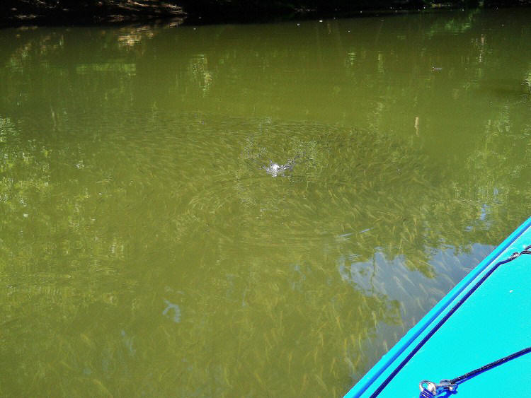
stone and gravel company up on the eastern bank, and it was here that the
minnows were really prevalent. They did seem to be a little sluggish for
some reason, though. Usually they'll dart away from you immediately but these were
just kind of moseying along. They certainly weren’t getting
complacent for lack of predators! I noticed plenty of birds
out "fishing" for them!
Next you’ll pass under some
bridges. First there’s one for US60, then you’ll see a railroad bridge which,
from a satellite map, looks so old that you can’t even see the track lines
anymore. Next comes an old bridge span followed by another railroad bridge,
then a road bridge for
High Street and finally come two bridges for Interstate 64.
I found it interesting today to see the changes in scenery as I went
from being in the city, to being in the suburbs and finally to being in the midst of
farmland.
Anyway, after the bridges the
stream begins to head in a generally southern direction in this large
“C” and at the 2 ½ mile mark I met a nice gentleman who was fishing on the bank
with his little dog. “I’m trying to see how far back this one
goes…” I said.
“Pretty far...” Was
the response.
I got the idea that I was
going to be paddling for a while!
Walkers Branch Road (or
County Highway 3) comes close to the water here on your right and it’ll stay with you as will a railroad track that lies
just beyond it. At one point there’s even an airport back there –
the Milton J. Ferguson Field a.k.a. the
Huntington Tri State
Airport - and I did see a little plane flying around as I
paddled.
Next you’ll make a little “S”
curve and pass under yet another bridge.
This one is for Walkers Branch Road, but perhaps the most pleasant views
I'd see were to come next in the midst of a sharp left curve where the water
began to get really shallow.
The wildflowers really seemed to like it here, yet I knew I didn’t have far to go. When
you get a scene like the one below you know you’re about to be heading back…
.jpg)
Ultimately, I'd hit one deadfall and get past it, then another, and when I hit a third one I was done. Where was I at the end? Somewhere in the midst of a left curve and, in looking at a map, I was fairly close to the Hershel "Woody" Williams Medical Center. 3,600 pulls on the paddle or about 4 ½ miles (yes, I actually counted. This is the method I use to determine how far back streams go. I've drawn a line on technology - no GPS, no smart phones, no social media.).
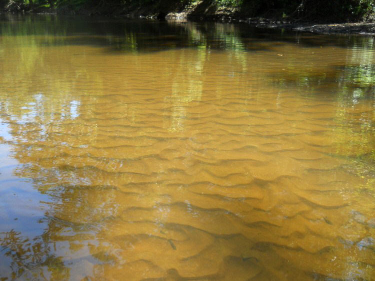
I paused here for a good long
time to appreciate how much the creek had revealed to me today, and as I did I also
noticed how the water cleared to reveal some fantastic patterns in the sand!
There were other things too
on the way back that I hadn’t noticed on the way up (probably because of all the
counting I was doing!). More wildflowers for example…

.jpg)
…and more great rural river scenes…
.jpg)
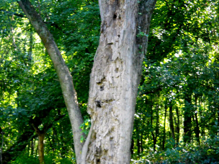
Along with one very friendly looking old bearded tree (s
Interestingly, as I was
paddling back out the man who had been fishing on the bank was still there and,
in the course of a renewed conversation, he shocked me by informing me of the fact that
my kayak was bulletproof! I sure hope I never have to put that
feature to the test! How in the world did we come upon this
topic? Well, he asked me what my kayak was made out of and I
told him “Kevlar”. I’m not too familiar with the substance but he apparently was.
He had a coat made out of it! Why would
anyone want a coat so strong that it’s made out of a plastic-like substance
strong enough to repel bullets? You wouldn’t think that such
a garment would even be comfortable! Well, if you’re
a biker it would make total sense. You’re not out for comfort
necessarily, but for protection in case of an accident. You
learn something new every day!
Back to the Ohio! As
I was coming out of Twelve Pole I first caught sight of a push boat up at the
mouth of the stream. He was heading upriver.
OK. That’s a pretty cool looking picture…
Then what do I see but the prow of a barge heading in the opposite
direction! Things seemed to be heating up! Let
me mention again how careful you’ve got to be out here. You
might not expect a second load of barges coming right after a first, but if you
aren’t you may just get knocked over! Imagine yourself
paddling away – “La, la, la” – then, WHAM! Check out the
second photo below!
.jpg)
.jpg)
At any rate, in this section
of the Ohio you’re essentially in a straightaway all the way to Huntington, and
at one point you can even see all 3 of the city’s bridges as you look
upstream. Huntington and it's outskirts comprise the southern bank
for pretty much this entire stretch with what looks like the suburb of
Westmoreland coming up first. You can’t really see many signs of
civilization, however, due to a mound of earth that serves as flood
protection. This levee seems to be an extension of the wall
in downtown Huntington and I did see someone walking up there.
There might be a hiking trail.
Meanwhile, and as mentioned, Burlington, Ohio
will be on your northern side followed closely by the
community of Chesepeake. These two communities seem to blend
together such taht you’ll have line of houses which stretches all the way to the
Huntington. Burlington appears to have
a little park up there, Burlington Commons Park.
.jpg)
Now as you can see from the picture above, I was to
encounter more barge-toting towboats in this area.
These included the Stephen T. of
Superior Marine and
the “Jincy” of Crounse
Corporation.
Crounse is pretty prominent on the Ohio and I’ve seen and written about
them a few times before. You’ll see them all over the river.
They have offices in both Paducah, Kentucky and Maysville, Kentucky – a
fairly wide stretch of river to cover! They’ve been in the
marine transportation industry since 1948.
Superior Marine was a new one on me. In fact, I really had to look for the name on this boat. It wasn’t where I expected. It was indicated toward the bottom of the prow. Superior, founded in 1977, is apparently headquartered just downriver from here in South Point, Ohio, yet they seem to have 3 branch locations, all in this general area: South Point at mile 317, Burlington at mile 312, and Proctorville at mile 305. The company looks to offer a wide array of marine services, almost everything you can imagine from transport to repair to construction to cleaning.
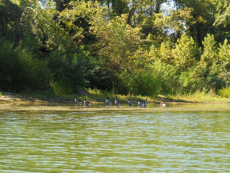
Geese!
Anyway, things start to get
really interesting once you get down to mile 312 - about the point where I took
the picture below…
.jpg)
First, what’s with that
viaduct for Four Pole Creek? I don’t know what that machinery
is at the mouth but it looks pretty foreboding! I didn't even paddle
in!What are those pipes?!? They look
like they could suck me right up out of the water, boat and all!
Seriously, I suppose this structure is part of the break wall system to
regulate the water flow, but I’d love to get more background on it.

Across from this in Ohio you’ve got
what looks like a large apartment or condominium complex which is pretty much
laid bare to the river. Following that there’s a very old structure with a
set of steps coming down to the water. Guess what this is?
It’s the former location of old lock and dam #28! I LOVE these old dam locations!
They fascinate me, and this one has a great article written about it
here. For the most part you wouldn’t ever know
there was such a significant structure at these spots but for the fact that you
can usually still see the remnants of steps. At this
particular spot it looks like one of the old lock houses is still intact, but it
looks different than others I’ve seen. Perhaps it was added on to…
.jpg)
Next comes a ramp which looks to be part of the old lock and dam grounds and then you’ve got Sandusky Creek (into which I only got a very short distance). Meanwhile on the other side there were several barges docked in West Virginia with the Matthew T. of Superior Marine acting as guardian. Notice that this is the Matthew T. and not the Stephen T. that I mentioned earlier. This confused to me at first and I had to do a double take on my pictures: “How could this vessel possibly be docked here and then pass me further upstream!
.jpg)

Next you’ll pass under the
first Huntington Bridge just upriver from mile 311. This is
the US Route 52 span which is considered to be the West Huntington Bridge.
It was completed in 1970, but it was here that I spotted a couple
interesting birds. One I’m almost certain was an egret, but the
other? A merganser maybe? Corcorant? Loon? I’m not
sure, but the water sure was clear here. I dipped my paddle
in all the way down and I could still see the tip of it. This
isn’t what you’d expect in an area where there’s quite a bit of industry.
I was impressed.
%20(900x750).jpg)
The area between this bridge
and the next was pretty quiet. You still can’t see much in
West Virginia besides the line of trees by the water and in Ohio there’s still a
line of dwellings, yet these are sometimes incredibly intriguing - not only in
the design but also in the grounds
and in how they might have dressed them up in nautical motifs.
One even had what looked like a rather elaborate playhouse overlooking the river
- either that, or it was a very small
guest house. There was another community park on this side
too as I heard the sounds of a football game being played.
As you near the second
bridge (the Robert Byrd Bridge completed in 1991 to replace an older span) you’ll find that downtown Huntington is starting
to emerge. Among the first things you’ll note are the Big Sandy Superstore Arena (now
called the Mountain
Health Arena)
which is right down near the water and the Huntington Riverfront Marina, a.k.a.
Holderby’s Landing (it's now closed). The latter lies just downstream from the ramp where you might have put in if you’re
travelling as I am. The arena looks to be the entertainment hub for
the city.
.jpg)
In
Ohio you'll find that the mouth of the Symmes Creek lies just past the bridge at
about mile 308.5
.jpg)
.jpg)
DIRECTIONS:
This is fairly easy. The ramp is right in the center of downtown Huntington in the midst of the David Harris Riverfront Park. There are, however, 2 distinct entrances and they're not connected so that you can drive between them. One of these is at the end of 10th Street, but you'll want to use the other which is just to the east of it between 12th and 11th Streets along Veterans Memorial Boulevard and just in front of Riverview Manor and the Heritage Center.
If you’re coming from the east on US60 you’ll take a left into the entrance which is on your left just past 11th Street. If you’re coming from the west, however, it's a little more complicated. What I'd do is type "Heritage Center Huntington WV" into Google Maps and when you drill down on the heritage center you'll see that when you make the last turn toward the river you'll go straight through the door in the break wall to access the park and the ramp.