.jpg)
Ohio River
Point Pleasant, West Virginia (Mile 265) to Cheshire, Ohio (Mile 257.5)
(Navigation Charts 156 – 157)
This ramp in Cheshire is
nice. It’s in a pleasant
spot and it comes complete with plenty of parking and a clean port-a-bathroom.
Check out the mussels at the bottom of the ramp too (third photo below). They look interesting, but if they're zebras
mussels I hear that they're supposed to be an environmental
hazard. Hopefully this is a more friendly type…
.jpg)
.jpg)
As I’m trying to keep this Ohio River navigation in an upriver order I’ll start from Point Pleasant and work my way up. As it turned out, there were quite some doings in Point Pleasant today. My first clue was the sound of music that I was hearing over the water on my way down. My second clue was a sweet looking paddleboat that passed me...
.jpg)
Well, when I eventually got down to Point Pleasant I found a ton of chairs set up along the riverfront along with a stage. What was going on? Turns out, I'd stumbled upon the beginnings of the Point Pleasant Sternwheel Regatta! This was apparently it's 22nd year. I floated around for a while trying to take all this in, snapping photos all the while. NOTE: Sadly, they stopped having this festival in 2019. The third photo below was taken in 2023.
.jpg)
.jpg)
.jpg)
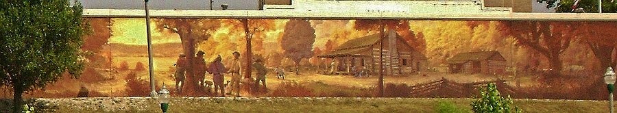
Something you might notice up along the flood wall in
town are
all the murals (as in the first photo below). These are distinguishing
characteristics of Point Pleasant. They're truly beautiful and are
definitely worth a closer look if you ever visit! You can get to them
.jpg)
.jpg)
.jpg)
On to my river narration... Point Pleasant, as mentioned, is the point at which the Kanawha River meets the Ohio. By itself the Kanawha runs about 100 miles. It’s obviously a main channel for commerce too as I saw quite a few barges lining its banks. It reminded me a little of the Green River down near Evansville, Indiana although the Green was so clogged with barges that I had no desire to paddle in at all – something I’ve never said before. The mouth of the Kanawha is a little better, but I'd still be very careful as a paddler here. NOTE: I've since paddled some of the Kanawha and I definitely wouldn't recommend paddling in from this point. I found an incredible amount of activity in the first couple miles to include push boats, motor boats and waverunners too. With that and all the barges crowding the banks it can be pretty dangerous.
At any rate, I think I encountered more barge-toting push boats today on the Ohio than I’ve ever seen before. I try to get pictures of all the boats I encounter, but there were just too many today. In fact, I'd encounter two vessels in Point Pleasant that I'd end up seeing twice today. The first was AEP’s James Morehead which I'd seen on my way downriver. It was heading back up. O-Kan Marine Repair's Little Marlene followed it and I'd encounter this one again on my way back upriver as it was coming back down. O-Kan's headquarters is located just downstream in Gallipolis while AEP, or American Electric Power, is a company that seems to have a very large “footprint” on the Ohio. You'll see their vessels all over.
Across from Point Pleasant (which extends for 2 miles up to the Old Town Creek at mile 263) is the community of Kanauga in Ohio. There are actually 4 different ramps along the shoreline here, one of which is public but I'm not sure which. From here you'll float under the Kanawha & Michigan Railroad Bridge (below) and then a couple businesses will become visible - the Sand Hill Coal Company and Shelly Materials. I can't find any info on Sand Hill, but Shelly is another company whose operations you'll see all over the river. This is one of their asphalt plants. "From Rocks to Roads" looks to be their slogan.
.jpg)
George’s Creek comes up
next on the Ohio side near mile 264. I got in a bit over 100
yards before being blocked by a deadfall, but what I found even more intriguing
was a business across the river in West Virginia.
It looked like a classic, yet it appeared to be out of business.
This was Point Pleasant Marine as per the sign, and from its appearance
it must once have been a pretty classy outfit.
.jpg)
.jpg)
.jpg)
.jpg)
Just past this at mile 263 is the mouth of another
stream - the aforementioned Old Town Creek which marks the
northernmost river boundary of Point Pleasant. At the same time,
and almost directly across the river, you’ll find a business that the charts
refer to as J. Hall Trust in Ohio (you’ll see this name again in the next upriver
section). I can't find any information about the business, but today the William E Porter of
AmherstMadison (spelled as one word)
was docked here along with another, smaller push boat that I didn’t catch the name of.
I believe this is the first time that I’ve encountered AmherstMadison on
the river. As per their website they’re headquartered in
Charleston, West Virginia and they offer many services to include marine towing,
construction and repair.
As for the Old Town Creek I
paddled in about ½ mile, encountering a very interesting old bridge just past the mouth,
yet when I eventually reached the point of a second, lower lying bridge I
stopped. I was essentially on the grounds of what
looked like someone’s farm. You’ll have to use your own
judgment when you paddle into these small streams, but as a general rule I'll
keep paddling until I either feel
that I’m vulnerable or until I get the impression that others might think I'm
intruding. I’m not, of course,
and I don’t want to give that impression. I only wish to
experience the peace and wonder of the outdoors.
.jpg)
…and speaking of wonder, below is an example (please
forgive the blurred picture but I hope you get the idea).
When I first encountered these in my travels I thought they might be
wasps - they spooked me. Now I know them to be little
dragonflies. These brown ones seem to be quicker and more
elusive than the others.
Here’s a nice
dragonfly identification website I found.
According to it this may be an Eastern Amberwing.
.jpg)
Just another half mile up and
you'll find Campaign Creek on the Ohio side. This one was navigable a good ½ mile and I
thought it
was a real beauty with a canopy of green covering much of its length.
You’ll first go under a pair of bridges, one of them for Ohio Route 7
which follows the river for this entire section, and then you’ll
pass a couple dwellings before things get a little more secluded.
I found the third sight below to be intriguing too. I
love the way plants adapt to their surroundings and this one seems to have given
new meaning to the term “drifter”!
.jpg)
.jpg)
.jpg)
Upon your emergence from this stream you might notice a pretty extensive amount of stonework along the Ohio bank. I’m not sure if it’s just for the dwellings that lie here or if it might be a remnant of a business of some sort. At the same time, if you look up ahead you’ll notice that the river is making a right curve and that there's a nice looking cleared out area visible atop a hill. This must be Campaign Bend as there’s a day marker here of that name. It made me wonder what the significance of the name might be? Campaign Creek and now Campaign Bend… Civil War relation, maybe?
.jpg)
Anyway, once you reach mile 261 things will get even more interesting. In Ohio you have the Kyger Creek entering the river (this is the one for which the power plant is named). This was another beauty. Look at this! Like the others, I got back almost ½ mile...
.jpg)
.jpg)
.jpg)
Meanwhile, in West Virginia you’ll see an incredibly intriguing abandoned house which has some very nice stone steps leading up to it. In fact, it appears that there might have been two such dwellings at one time because there are two sets of steps. Why was the place abandoned? It still looks awesome! In fact - might there have been an old dam here? I know that lock houses – at least the ones I saw on the Kentucky River – came in identical pairs… NOTE: This is, of course, the site of old lock and dam 25! This was my first encounter with one of these on the Ohio River.
.jpg)
Next you’ll begin to the feel the power of industry. In fact, it looks as if all the structures you see could be part of the same facility. I thought this at first, but there are actually two power plants here. The first is the Kyger Creek Power Plant which belongs to the Ohio Valley Electric Corp., while the second (the one with the nuclear reactors) is American Electric Power's Gavin Power Plant. The latter lies immediately downriver from the Cheshire ramp that I used. According to a Wiki entry Kyger is the older of the two, having been built in the 1950’s. There's also an interesting article about the AEP plant as it relates to the town of Cheshire here. Apparently the company bought the town in 2002 after the residents complained of pollution! It's not completely abandoned, however. Some of the residents decided to stay.
.jpg)
Each of these facilities seemed to have a push boat dedicated to it. Kyger had the Fred Shedd and Gavin seemed to have McNational, Inc.’s Ed McLaughlin today. I’ve written about McNational before as I've encountered vessels from their McGinnis division at other times. As per their website they provide transportation, equipment and repair services to the river industry.
.jpg)
Passing Kyger my attention
was drawn to 3 grain elevators that were being operated on the shoreline. They
appeared to be unloading coal from the barges but they were doing it in
completely different ways. The one furthest upriver seemed to
be operating with impressive efficiency. Not a speck of coal
seemed to be dropped. The second seemed to be going a little too
quickly. It was dropping quite a bit. The
third? No evident pattern. A study in
contrasts…
%20(2).jpg)
There was a lot of
interesting equipment to see in this area as well. I found myself most
drawn to this particular machine…
.jpg)
…and the most scenic of the
pictures in my opinion were those that I took from incoming streams on the West
Virginia side. The first is mostly of Kyger from
the mouth of an unnamed stream while the second is of the Gavin Plant from the
downriver mouth of Eight Mile Island…
.jpg)
.jpg)
Meanwhile - what’s happening
on the West Virginia wise with all the industry in Ohio? Well, not
much but that’s not a bad thing. Look at
the pleasant beach-like areas with their rocky shorelines!
The photos below
were taken at about the spot of the Hogg’s Landing light and day mark…
.jpg)
.jpg)
Two more push boats passed me here as well – the Bill
Stile of Campbell Transportation and the Dirk Taylor of what looks to be SMI.
I encountered Campbell in the last downriver section but SMI was new to me. Unfortunately, I can’t find any
information on this business to match with the logo I see in the picture I took.
If anyone could enlighten me I’d appreciate it.
Last but not least was Eight Mile Island and going around the back of it took me about 1/3 mile. This little island is so close to the West Virginia side that you'd think it was an incoming stream. Of interest was a very old barge that looked as if it could have been left here to rust 50 years ago. Something else was an old bridge that might have once led over to the island.
.jpg)
DIRECTIONS:
This is another super-easy
one since Cheshire is such a small town. Cheshire is where
the Kyger Power Plant is located. All you have to do is
follow Ohio Route 7 down from Marietta, up from Huntington or just get to the
route and follow along it until you get to Cheshire. The ramp
is in the town park at the end of East Poplar Street on the northernmost side of
town. County Road 39 will also take you directly to this
ramp.
River Museum:
I’ve just returned from visiting the
museum and what a pleasant experience it was! First of all, the ladies who run
it are very gracious and helpful. I was encouraged to take my time in order to
explore everything they have to offer. …and what do they have to offer, you ask?
Well, just about everything a “riverlorian” could ask for! First of all, they
have a great many displays on the history of the river and among these was one I
found particularly intriguing– a section on the old show boats (including the
Majestic). They also have a separate display regarding the Silver Bridge
collapse (which, by the way, these ladies helped write the book on: "The Silver
Bridge Disaster of 1967". Copies may be ordered directly from the museum.)! I
also encountered a remarkable number of model boats on display which included
just about every kind of vessel you’ll find on the river.
Not enough? Ok... Do you want to see what kinds of fish are swimming in the water? They’ve got a large aquarium in a separate room which is big enough for you to see some up really close and most of them are quite sizable! In fact, I was so mesmerized just looking at them that I must have stayed in this room for a good 15 minutes alone. Do you want to do some research on the river and its’ history? Well, they’ve got a really impressive library room which covers just about every topic you’ll find relating to the river - be it river vessels, commerce or history – and they’ve also got a little book store and gift shop. Last but certainly not least is their boat simulation room - and I was truly mesmerized by this. You can actually get a feel for what it’s like to pilot various vessels on the water! Me, I spent all my time as a “towboat captain "just because these are the vessels that I see most in my travels, but you can opt for different choices. Anyway, what all this amounts to is one truly fantastic museum and I highly recommend it to anyone!