.jpg)
Ohio River
Syracuse, Ohio (Mile 245.5) to Racine Lock
and Dam (Mile 237.5)
Thursday, September 13, 2012
(Navigation Charts 159, 160 and 161)
The ramp I used for this trip
is located in
Syracuse, Ohio (full directions below). This is a really nice ramp
with a very interesting little ecosystem off to the left when you reach the
bottom.
This location is also part of the Syracuse Community Park so there’s
plenty of parking available here.
Today I got on the water,
headed over to the West Virginia side in order to get the best pictures of
Syracuse and the nearby community of Racine, and then began paddling upriver. From
the point of the ramp you’re at mile 245.5, and from an upriver perspective what the river
will do here is make a right curve, to then follow with a long 4 ½ mile straight
stretch. Following that, you'll have a second right curve, to
finally arrive at the Racine Lock and Dam up at mile 237.5. You’ll find, by the way, that
the bulk of my pictures were taken from the vantage point of one looking
downstream as this was the best way to take advantage of the sun today. The first
shot below was taken looking back downriver toward the ramp while the second is a general shot of Syracuse, Ohio.
.jpg)
.jpg)
.jpg)
Syracuse is, as one might
expect, a very small town with a population that’s purported to be a little less
than 1,000. It's got a nice looking little café called the
River Way Cafe if you're looking for a bite to eat after a day of paddling, and
from down on the river what particularly intrigued me was the shot below. Quite a bit of landscaping has
been done here and I’m wondering if this might have been part of an
old town park (one older than the one from which I put-in). Meanwhile, on the other side
of the river, there’s another little town called New Haven, West Virginia.
This community is supposed to be a little larger than Syracuse but I couldn’t see much of it at all from the water.
.jpg)
.jpg)
Reaching the mouth of the
Little Broad Creek at mile 244 I turned around to take the first picture below.
As for this little stream, I found it to be navigable for roughly 200 yards
(back to the point of a bridge span for US highway 33) and as I was paddling out my eyes were
met with the scenes like those in the second picture…
.jpg)
.jpg)
Check out the river bank in here too! I’m wondering what kinds of creatures might live in all those holes you see?
.jpg)
Anyway, just upriver from this creek you’re going to start to see quite a bit of industry on the West Virginia side as you make your way around the first right curve in the river. Coming up is a very large American Electric Power (AEP) operation. At the time of this writing it actually consists of two power plants - the Mountaineer Power Plant (which is staying) and the Philip Sporn which is set to be demolished. The whole thing runs for nearly 3 river miles on the right side and, needless to say, I paddled around this area very carefully well - on the Ohio side. :)
You’re apt to find several vessels in this area and I initially encountered two, both of McGinnis, Inc. One was approaching me as I paddled (the Bruce D.) while the other had passed me heading toward this point on my last downriver trip (the Mr. King). They converged at this point...
.jpg)
Below are some more photos from different points around the power plant, all taken from the perspective of someone looking downriver. In the last one you'll see the towboat Andy Mullins (it's the one with the red crane) around the still-remaining Sporn Plant which is the structure at the far left.
.jpg)
.jpg)
.jpg)
.jpg)
Meanwhile, across from all
this in Ohio, your eyes will meet with some very pleasant rural scenes, amid
witch you'll spot an old lock and dam location at mile 242.5. This one has been turned into a campground -
Lock 24 RV Park.
.jpg)
What really floored me
here, however, was
a phenomenon that I didn’t notice until I was returning later in the
day. It seemed as if there was a large, long, shimmering
creature moving just underneath the surface of the water – one that had orange spots! It took me a while to take in this scene.
What was really happening?
Well, the “creature” was the old lock wall, but why did it seem to be
moving? I looked closer and saw the reason...
It seems that a school of minnows had been swimming here and that they’d
apparently been separated by the wall which lies only about an inch or so under
the surface of the water. Well, it turns out that the motion
I was seeing was due to the “strays” trying to struggle over the wall to join
their comrades!
.jpg)
As for the orange spots on the wall (do you see them in the bottom of the picture?) I can only speculate that they were made as boats bumped against the wall and produced chips. The resulting orange hue might be due to some form of algae partial to such spots. That, or perhaps it’s due to some type of mineral exposed under the surface of the rock. I’d be interested to know for sure if someone could tell me. My email address is on my "About Me" page.
.jpg)
Anyway, once you pass the last of the AEP operation on the West Virginia side you’ll be in the midst of the community of Racine, Ohio. I glanced up through the shoreline trees at one point and saw a particularly intriguing old building here. It appeared to have the name of “Cross - Established 1860”, but there’s also a nice little beach here too. Then, going just a little further up, you’ll spot the town boat ramp. This is a multi-lane affair which appears to lie in the midst of Star Mill Community Park.
.jpg)
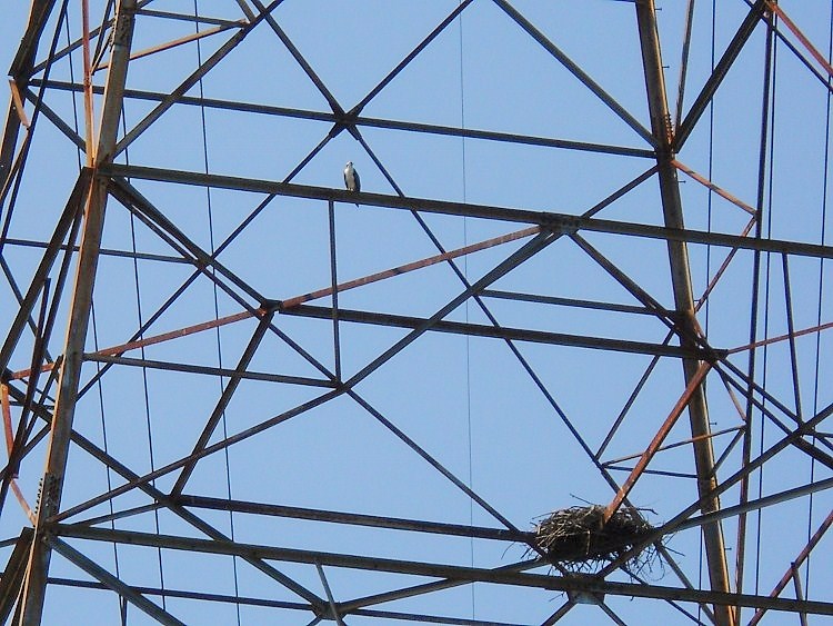
Continuing on, you’ll see
some power lines up near mile 241. Here lie some moorings on
the Ohio side for a business that I can’t seem to find the name of, while at the
same point in West Virginia you’ll find an AEP water intake and what looks to be
a grain storage location. When I got to one of the power line
towers, however, I spotted something a little more interesting - a huge nest
with the “owner” perched on it! This looks like an osprey
to me, but I’m not sure...
The West Creek enters here in
West Virginia too. It wasn’t navigable to me, yet among the
alga that thrives in this section you’re liable to see some gar out “fishing”.
Do you see the gar in the center of the photo below?
These fish are able to camouflage themselves incredibly well.
Look how they angle themselves so as to better blend in and disguise
themselves from the minnows they’re hunting!
.jpg)
From here on out things will get pretty quiet with only a couple light and day marks to interrupt your reverie as you round a right bend to make your last 3 miles up to the dam. In this area you’re apt to find the beaches in West Virginia to be pretty inviting. Some of them even make for convenient spots to stop and rest as the heron below was doing. The vessel coming and going in the other two shots is the S. W. Price of AM&O Towing.
.jpg)
.jpg)
.jpg)
As for the Racine Dam, I
can’t seem to find a lot of information on it other than what’s on the Army
Corps of Engineers site
here
yet I found the structure to be just as formidable-looking as the others that
I’d encountered - and I certainly tried to steer clear of AEP’s James E. Pinson
here as the vessel had to make a wide curve toward me to enter the lock chamber.
.jpg)
For me, the most intriguing
feature of this lock and dam was the very pleasant grove of trees lying on
the Ohio side. The areas around the dams aren’t usually so
inviting!
.jpg)
.jpg)
From here I headed on back.
I’ll explore the area above the dam on the next trip, but what follows
are some more of the pleasant scenes which are typical of this section (yes,
those are all blue dragonflies in the second photo and a flower pot/boat in the
third!).
.jpg)
.jpg)
.jpg)
.jpg)
DIRECTIONS:
Google Maps makes directions so easy. Simply look up Syracuse, Ohio and drill down on the Syracuse Volunteer Fire Department. You'll find the ramp in the midst of Syracuse Municipal Park at the end of a very short lane called Marina Street. There's not a ton of parking, but a good enough amount in a paved lot.