Dam
12 to Calloway Creek (Mile 213)
When I first paddled this pool last year I thought that there was only one put-in between dams 12 and 13 - the one at the Riverview Restaurant under the KY52 Bridge in Irvine. As a result, I ended up going 6 miles one day and then 34 on an out-and-back trip the next! There was a silver lining, however. I might never have known about the ramp near Bybee Pottery if I hadn't done this. I'll describe this ramp in the next downriver section.
Anyway, I began today by heading up to dam 12 from the ramp at the Riverview Restaurant (formerly Howell’s according to the charts) around
After getting my boat in the water I headed up to
the dam where I immediately noticed a lot of water pouring over it. This
had been the case on the last upriver section as well, but from this vantage
point I also saw that the water was pouring over and through the lock gate as
well as the dam itself. This had
not been the case at dams 14 and 13 and I wasn’t sure that this should be
happening. I was thus more cautious than usual, if that’s even possible.
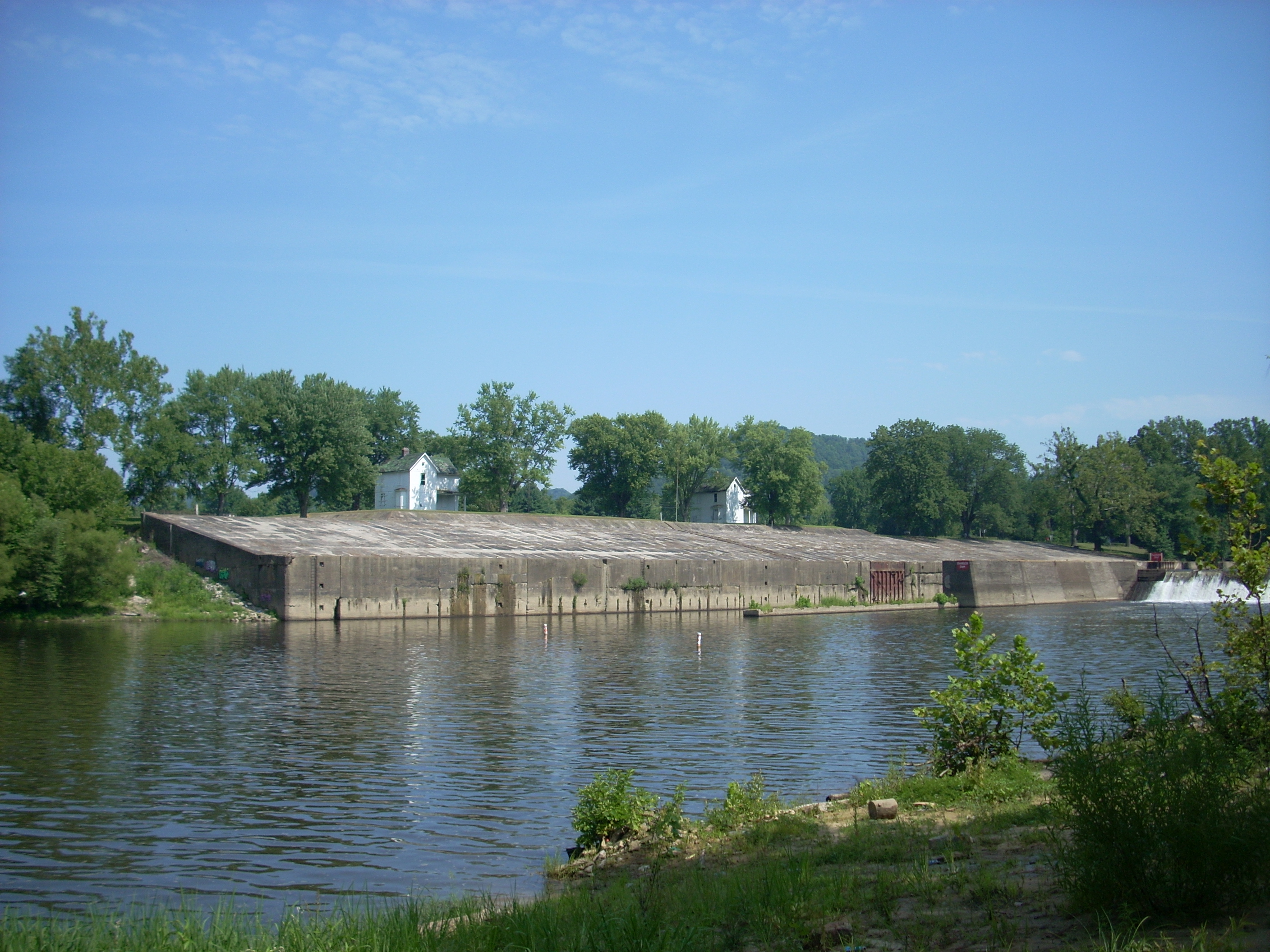
There’s a nice beach on either side of this lock and dam, and I stopped at the beach on the dam side first intending to get a look at the Little Doe Creek which I found to be a couple feet wide as it came in over the sand. After this I carefully paddled over to the other side to see if I could reach the top of the lock and get a picture of what the portage would have been like from the upriver side corner - the one I hadn’t been able to get to on Friday. The beach made the task easier as I was able to “park” the kayak and walk across the sand to get a better look. There was some undergrowth to negotiate but it wasn’t too bad, and once at the top I was able to get an appreciation for just how beautiful this spot is!
Dam 12 is in an incredibly attractive location! There are 2 fantastic old lock houses (now sadly graffiti’d and in need of some TLC) but they lie in the midst of a cornfield and a golf course. It's beautiful, and the charts also indicated that the beach I’d just walked across used to be known as Ravenna Beach, supposedly a public one. Needless to say, I went crazy snapping pictures as I imagined all the people who might once have been basking in the sun here! By the way, the portage I was curious about appeared to be do-able if one didn’t mind a fairly steep 7-8 foot climb through some trash and underbrush.
Starting downriver from this
point
it immediately goes to the dogs – literally. Apparently the beach on the
lock side is part of the Dog Rock Bar on Dog Rock Bend which is the site of –
what else? – Dog Rock where the Dog Branch enters the river from the left!
Wow! Or should I say: Woof!
The Dog Branch wasn’t really even recognizable as it entered over a rocky shoal, but it occurred to me in seeing some more rock faces at this point that there were more and more of these outcroppings becoming visible on the river.
This is not yet considered to be the palisades area though. That will begin somewhere aroundAt any rate, there’s an interesting
concrete structure of unknown (at least to me) origin as you pass around
Dog Rock Bend, and the Chamberlain Creek comes in between mile 220 and 219.
On the charts this creek appears to separate the towns of
Quick Shoals Bar should be on
the left side of mile 219 with Quick Shoals on the right, but neither appeared
to be in evidence on this day. There was, however, another
interesting concrete structure further down which appeared to have once been
some kind of swimming platform. It come complete with
an elaborate amalgamation of steps leading down to it, some of which even formed a circular staircase.
Someone had sure gone through a lot of time and expense to build all of
this, although it didn't appear to have been used in some time. Things like this
always intrigue me! I would love to have been on this river in the first
half of the 1900’s!
Something else that intrigued me was another old structure I saw on top of the right side bank after this. I thought it could have been the Irvine-Ravenna Municipal Water Intake because the charts indicated that it would be at about this point but I wasn't sure. It consisted of 2 old round brick structures which were connected in the middle by a wall of concrete. The whole thing looked like a pair of binoculars stood on end with a little house atop these brick cylinders. Unfortunately I could not get a clear picture to share.
It was at this point on the other side of the river near the mouth of Station Camp Creek that the Indian’s Warrior Path is said to have crossed the river. Talk about history! I decided to paddle up Station Camp Creek. It was similar in size to the Miller Creek I'd passed back at mile 226 and on the first part it, too, appeared as chocolate milk. Chocolate Milk Creek #2!
There’s actually an incoming
stream entering into Station Camp from the right a few dozen yards in near a
bridge. I paddled into this a little until I was blocked by what looked like a beaver dam, and when I got back to the main
creek there were some cows on the other side. I tried not to disturb their
peace and quiet.
Continuing back up Station
Camp, you’ll meander through some nice little walls of shale on the left side.
I unfortunately found, however, all manner of appliances and trash cascading
down these walls. Refrigerators, stoves, ovens – you name it.
Overall there were a few deadfalls to negotiate on this creek, but I had
nothing major until I got about a mile up, so this had been the longest side
stream paddle yet.
On my return I stopped and
tried to finally get some good cow pictures, but it was in taking my first
picture of one down by the water that I quickly came to realize that it wasn’t a
cow I was taking a picture of. It was a bull! He was coming down to
confront me apparently. “Hmmm… those horns… kinda sharp looking…yeah, maybe
I’ll move on!” Thus, I moved VERY quietly and peacefully on my way – and well on the
opposite side of the bank!
.JPG)
When I emerged from the creek,
I paddled down to the point where the ramp (the one I put in from) comes in
right under the KY52 Bridge. Here on the left you’ll see your
first marina on the river (assuming you’re paddling downstream like I am and not
up, of course). 12 house boats and 6 power boats were docked here when I
went by. The charts indicate that this is the River City Marina, although
it might have changed names like the Riverview Restaurant – I didn’t see a name
on it. The restaurant itself is on the same side (in
.JPG)
Making a curve right after
mile 218 I saw more of those old bridge piers. I’d now seen them along mile 248 at
[UPDATE 2013: I've just received an email from an interesting gentleman who states:
"Near the town of Irvine you made note of old bridge piers that were still there, located downriver from the current bridge. There used to be a toll bridge in that location which was run by my family many years ago. My great-grandparents lived in a house that is located in West Irvine at the foot of the bridge and they operated the toll bridge (house is still there). William Ellis interviewed by grandfather about it in his book on the river."
Something else interested me here
as well. There were many stone slabs that looked a bit out
of place in their relative symmetry to the other rocks, you see. Upon closer
inspection I noticed that they also had indentations in them like they’d been
drilled into. My guess was that they had left the ruins of
another old bridge here.
Up to this point the scenery had been that of a city in the midst of farmland
but that will change once you get past mile 217 and the city of
After passing under a fairly modern-looking highway bridge (which is not on the charts, by the way) at mile 216.5, the White Oak Branch comes in. I paddled into this less than 100 yards before stopping at a bridge for the railroad track. This bridge seemed similar to the one
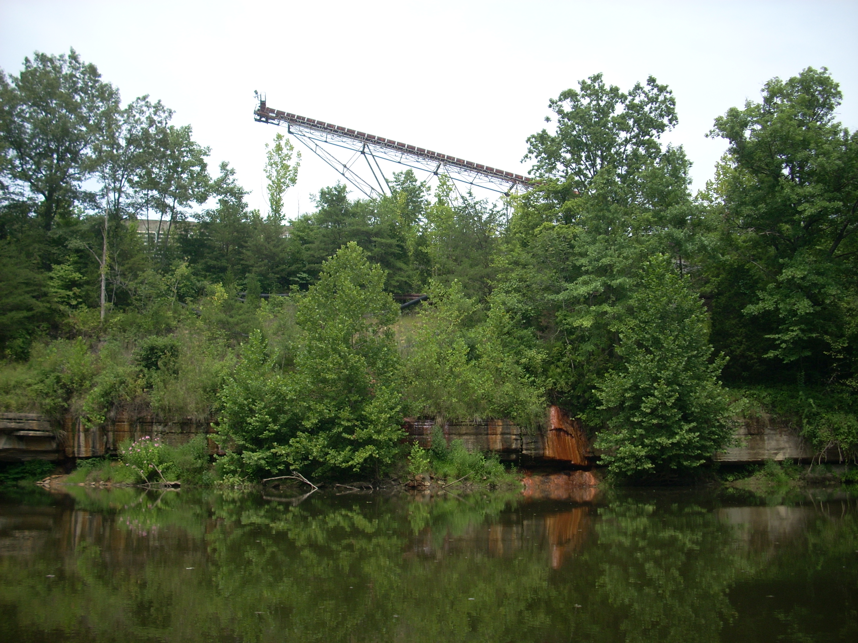
inUpon reaching mile 216 you’ll begin to see signs of grain elevators above the trees. Somewhat incongruous, they do look pretty cool. They’re physically located closer to mile 215 just before some power lines cross the river - the location of Cubbard Rock. The charts also indicate that the community of Calloway Crossing is up there somewhere. The rock was oddly rust colored as water dripped down from it, and the hum of machinery was all that I could hear from what I guessed was a quarry. All this seemed odd because it looked like this could have once been (and it could still be for that matter) quite an operation, but now the equipment just seemed rusted and possibly out of use. Were it not for the hum of machinery I heard, the whole place seemed abandoned. All this, added to the peaceful solitude, gave me a strange feeling like I could be in some kind of doomsday scenario in which I was the last person on earth! Has anyone else ever had this feeling or is it just me? :)
Upon rounding a bend at mile 215 another odd sight caught my eye. A little unnamed stream had completely eroded through an outcropping of shale - right down the middle – so it was like a sand bar but made of shale. Really interesting! This would have been a good place to stretch, but I noticed quite a few bees so I didn’t chance getting out.
.JPG)
I went up
another mile; made a curve left, and then passed through another mile long
straight stretch until I reached what I decided would be my stopping point - the
Calloway Creek at mile 213. A few hundred feet up this creek I met with
another rail bridge, this one extending well into the air above, and just ahead
of it was another jam-up - I headed back out.
On my trip back
to the ramp I noticed at least 3 different kinds of wildflowers. Some were
colored red and looked like they had 3 leaves. Some looked like pink roses
but they didn’t bloom from the same kind of plant (they looked like the poppies
I’ve seen pictures of in
.JPG)
.JPG)
.JPG)
DIRECTIONS:
KY 52 to KY 89. There’s a bridge at this intersection. The put in is on the Southeast side of this bridge. You’ll see a road going down the side of it. This will lead you straight to the ramp.