2008
Bailey Run to Dam 5 (Mile
82)
I couldn’t do it. I couldn’t get out of bed
early enough to make a portage of dam 5 worthwhile in assisting navigation today. It’s a lot easier to sleep when the weather gets cooler isn’t
it? It’s also harder to wake up! At any rate, today would be a short
trip and that was fine with me. I’d waited quite a while to paddle here
and I’d be able to fully enjoy it.
On the way out to Tyrone from Lexington I stopped to take a look at the train I'd seen the last time I came out. It turned out to be part of the
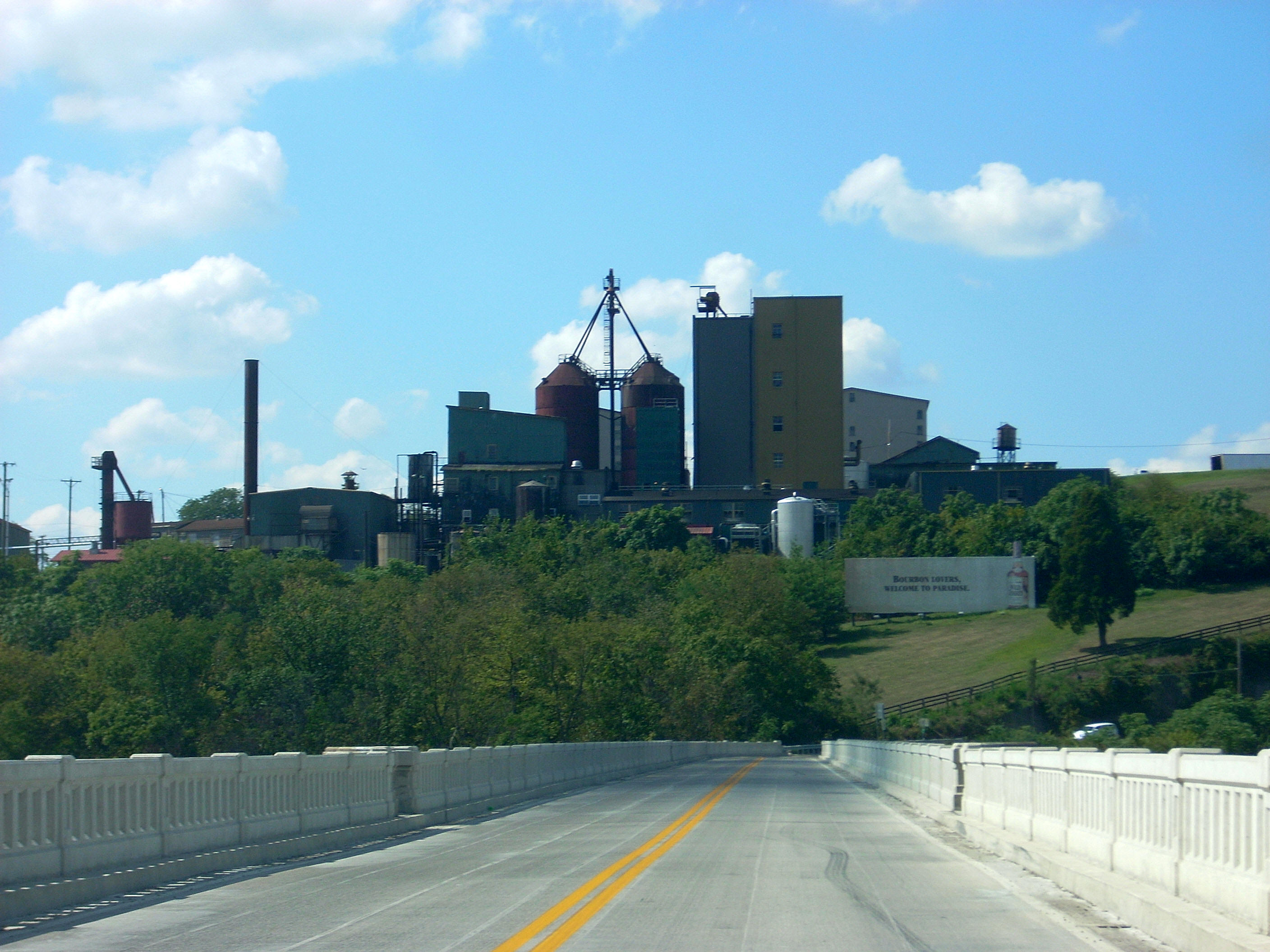
The Blackburn Memorial Bridge, meanwhile, is the road bridge. Note here the clever slogan on the Wild Turkey billboard sign! It lies straight ahead so as to have a captive audience if you're heading South. It reads: “Bourbon Lovers, Welcome to
Anyway, when I
ultimately arrived in Tyrone there was no missing the ramp this time - and the ducks
I'd seen were still there too! I put my boat at
the bottom of the ramp, drove the car up and came back down with my gear. Doing
so, I noticed that those ducks were checking out my boat!
It was funny. “Hey! Leave my boat
alone!”
One thing about this
location is that it’s quite industrial. The
Kentucky Stone Company Quarry is here according to the charts, although in 2019
it looks like it's part of
Hanson Aggregates. The
distillery is also here, of course, as is a steam generation plant. All of
these appear within a mile of the ramp (heading
downriver), but I began the day by paddling into Bailey Run.
I got in about 100 yards, in the process noticing some large stones near
the entrance. These might have been part of a structure associated with the
quarry at one time, but I could tell that
unlike the quarry just downstream from
Anyway, once you get back to the river you'll find that there are 4 straight water intakes from mile 84 to mile 83 - 3 of them come almost immediately (one for the quarry, one for the distillery and one for the city of
.JPG)
.JPG)
After you pass the bridges
you'll find that the river will slowly curve right and it was in here that I
began to hear quite a bit of noise from the direction of the steam generation
plant. Most of it was a garbled voice over a loudspeaker. This was
quite a
new noise for me on the river and I had the strangest urge to say:
“Yeah, I’ll have a cheeseburger, large fries and a medium drink please.”
As I slowly made the curve the
plant edged closer and closer into view on the right with each downriver paddle stroke, and
once it was fully revealed I found it to be quite a structure. It was about
as large as the one back in Ford and it had 2 brick and concrete structures
down at the river's edge, one of which had grates.
This, I guessed, was the water intake and there were some guys here enjoying their lunch
break down by the peaceful
water. I gave them a wave from across the river.
Also of note here was an old paved ramp which looked like it hadn’t been
used in decades (in fact, there was another further down which looked even
older).
.JPG)
Just downriver from the plant
I found it's water discharge, and while I recall that the Ford Steam Generation
Plant had a torrent of a discharge, this one was tamer. I paddled in a little
bit... Sure enough, the water began to get quite warm and the
further I got the more I began to wonder if the heat might actually start
to melt my boat! (This would be the last running water of the
day although there would be 2 more unnamed streams which would enter further
down.)
Once the curve begins to straighten out you'll see the dam down at the end at mile 82. The
paddling book I was using indicated that this was the most difficult portage on the Kentucky but that didn't seem to be the case today. In fact, I found a spot just at the end of the lock side where I was able to walk right up and, since the dams seem to be getting lower and lower the further downriver I go, the climb didn't seem that bad. One of the old lock houses was still here – at least I think it was an original lock house. It did have some additions which probably strayed from the initial look, however. It also appeared to be lived in. I treaded very lightly.
This lock appeared to be concreted over like the one at dam 6 was, and here too there were some large rocks at the bottom of where the water was flowing over the dam. Some power boat fishermen out trying their luck here. This is yet another nice spot with a downriver beach that I'll describe in more detail on the next trip.
.JPG)
.JPG)
Having seen all this I headed back, along the way noticing some more of those orange blobs with white spots. I frequently see these attached to the bottom of underwater tree branches and I still wonder what they are. I assume they’re eggs of some kind, but I'm not sure. Then, once I arrived back at the ramp I just kind of floated around for a while, relaxing and taking pictures. The ducks were asleep on the bank at this point, and I found some more minnows. :)
.JPG)
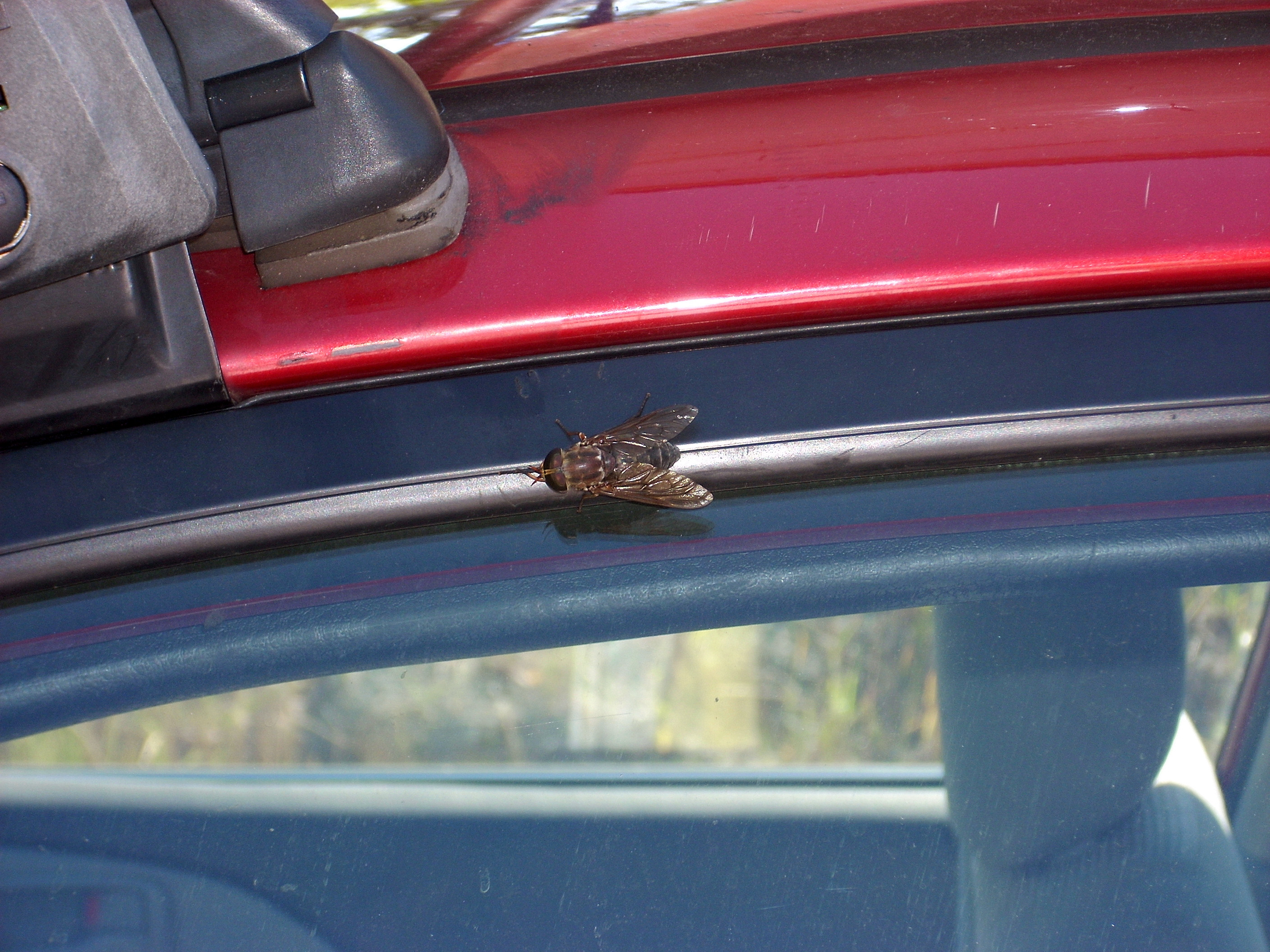
Back up at the car, I saw what had been buzzing all around me on the water! I’ve mentioned it before, but up until today I hadn't been sure of what was making the noise. Now I know that flies are probably the cause - and they're HUGE as per the photo below at perhaps an inch and a half long!
DIRECTIONS:
Take US62 in Kentucky to
KY1510 and then follow it south to Tyrone. After you cross the
Kentucky River you'll make the same left turn that you'd make if you were
going to the Wild Turkey Distillery. Pass a rock quarry on
the left and then make an immediate left after the bridge. This will lead
you straight to the ramp.
.