.JPG)
2008
Archaeology – a search to uncover and study what
remains of the past in order to get a better understanding of how things used to
be. At least that’s my definition. To me, the “past” in such regard
doesn’t have to be millions of years ago; it can also pertain to uncovering
something from only a few decades back. Well, speaking
to that point, I’d say that on this Kentucky River journey I’ve come to quite a few
places that have had a lot of history. Still, I might have to rank the area around
Getting to the ramp was confusing today, however. I think the navigation charts had it in the wrong spot (although it looks correct on the 2014 charts).
Adding to my confusion was the fact that you’d never know there was a ramp here unless you were really looking! Full directions are below, but as you're coming in on US68 and you near the Brooklyn Bridge over the Kentucky River there will be an old store on the south side (this was a furniture store when I came and it also used to be a restaurant called Ward's Landing). Right after this you have to keep a keen eye out for a gravel road called Palisades Road which is on the same side (it wasn't marked when I came). This will take you to the ramp which comes up almost immediately.
This ramp once belonged to a place called the
Palisades Adventures Marina which appears to have been closed for quite some time,
even though an old sign
I saw indicated that they used to run river cruises. The old restaurant
too, looked like it might have been
quite nice when it was in business – as nice as any on the river. There
were still some attractive grounds here and a gazebo which indicated that they
might have had some outside seating capacity too. This must have been a
classic!
Meanwhile, across from all this is a fenced in area that covers up a cave in the rock. Incredibly, there used to be a gas station and convenience store here called the Chinn’s Cave House! The store was in the cave! You can only see the ruins by the side of the road now, but I've seen old post cards online showing what it used to look like. What an incredible place this must have been! In fact, this whole area is positively fascinating! I'd give anything to have seen it 50 years ago, yet it now has the feel of a once thriving but now forgotten location - something that only adds to the intrigue!
When I came there
was an interesting, half finished building at the ramp which typified this. It looked
like it was meant to be a house but I’m not totally sure. It had 3 stories and it was obviously meant to be
something quite grand. It could actually have been the Palisades
Adventures main building at one time, but it has the look of something that was started with great
hope and expectation only to succumb to a lack of money to finish it or a lack
of business to support its continued construction. I wonder what happened
to
Anyway, once at the
ramp it became clear that the parking would be kind of willy-nilly.
First I had to find a level spot from which to get my boat and
gear down and, like the last time, I had to park my car at an angle partially
blocking the ramp in order to do this. No problem.
The ramp seemed kind of remote. It wasn't likely I'd see anyone in
the short time I'd be blocking it… Well, as I was coming
back up, guess what? A truck and trailer was backing
down the ramp! Impossible. The moment was a bit awkward, and as the
driver stopped I apologized to him. Luckily he was nice,
and we’d end up seeing each other on the water a couple more times during the
day.
Dam 7 at river mile 117 is the one with the hydroelectric plant I described in the previous upriver entry, but at this time it couldn’t have been garnering too much energy - there wasn’t much water coming over the dam! There were the 2 boats and another fisherman on the bank at the lock side when I arrived (this one has another nice beach). I couldn't decide which picture to put up so I put up two...
.JPG)
.JPG)
On the opposite
side you'll find a fairly large rocky shoal at the base of a palisade, and as I headed
back downriver from the dam this palisade began to recede a little bit to let in
some trees. Conspicuous in it's absence, however, was the middle layer of
this little forest. There was underbrush along with the trees, but not too much
mid-level growth. Thus, from up against the shoreline I was able to see
right through to the cliff base. The area reminded me of the one at Wagers
Bend way back at mile 222 in
.JPG)
Roughly a mile down from the dam on the right
you’ll see a rock fence by the waters edge which is interesting. There’s
also a wall made of wood. Part of the rock fence is now submerged but
maybe this was some kind of retaining structure? Both look like they’ve
been around for quite a while and the stone wall, in particular, seems to have
been very well put together. Atop the bank here are a few
dwellings between the river and the Cliffside which lies not too far back.
At about mile 115.5 the palisade on the left will begin to recede, ushering in a line of houses 2 miles long which reaches all the way past the boat ramp to the
Mile 114 contains the Wilmore Water Intake according to the Jessamine County Kentucky River Task Force historical markers. You'll find these on both sides of the river here as, in addition to the water intake, this was also the point of a buffalo crossing which later became the site of the Fulkerson Ferry. This ferry was first used and later owned by the Shakers. Once they did own it, it became known as the “Lower Shaker Ferry” while the one back at High Bridge became the Shaker Ferry proper. Very enterprising, these Shakers! They also once had a warehouse here on the left side. Also note in the picture below some of the palisades you'll pass under in this section.
.JPG)
At the
.JPG)
The shoal immediately downriver from this point was known as Singleton Landing. Yet another ferry (the Cogar Ferry) operated here. It sure seems like there were a ton of ferries on the river, doesn’t it? At first this seemed odd to me, but I eventually came to realize that these were the only ways to get across the river way back when. The people who ran them charged tolls to make a living, and there were other businesses that sprang up around them to support the needs of the people who came through. Sometimes there was even more than that – this particular spot once had a meat packing facility!
It
looked like a fairly easy climb up the bank to get to the bridge tunnel here so I
tried it.
I didn’t quite reach it, but the side jaunt did provide a good break and
stretch period. There were trails up along the riverbank
too. I wondered how far they went… For that matter, how far down this river
could you actually hike??? I know that the Sheltowee Trace
touches along the river up in
.JPG)
For the next 2
miles or so, the rock faces were receded from the river. You could see
them on occasion from different sides, but in general they'll be hiding from you
under a veil of trees that in this early Fall season will slowly but surely gain
more color as the days move toward October.
Next, just
before reaching a
power line crossing at mile 111, there’s supposed to be something
called the Weeping Willow Stone House on the right. I couldn’t quite see
it through the forest. Another mystery... [Clarified
thanks to George Dean of Jessamine County. This was not a rock formation
but an actual house. Thank you, sir!]
There's a fairly sharp curve to the right at mile 109.5 and there's a lot going on here. There used to be a lot more. As for the former activity, there used to be a couple mines in here on either side of the river - a fluorspar mine on the right and a calcite mine on the left, neither of which I could see. Curses! Drat! Oh, well... Egad!
The Shawnee Run enters here too. I could see that! Yay! It’s really nice. I got in 100 yards. As you look at it, it has a nice flat and rocky spot which looks like it would be a nice overlook for Mundy’s Landing which is across the river here. The palisades, for that matter, are back too - and right against the shoreline. Looking across the water, I noticed a gravel boat ramp. I believe this was Mundy's Landing.
The sight which
next greeted me on the right at mile 109, however, was completely and totally
unexpected. It was what looked like a massive, old fashioned, southern
plantation house – and it was right at the shoreline! This turned out to
be the old
Chinn’s
.JPG)
A half mile down from this, the Rocky Run enters on the left side. This looked to be yet another beauty, but I couldn’t paddle in far - only about 20 feet. The stream was lush, green and inviting and I was bummed I couldn’t get in much further, although it did look like it ended fairly quickly. There was supposedly another fluorspar mine across from this, although I couldn't see it.
.JPG)
As you round a right curve in
the river next, the Twin Chimney Rock will become visible on your left. All but
the very top was blocked by foliage when I paddled by, but this is a stand-alone
rock formation which has a crack right down the middle – hence the name.
This is at mile 107.5. After this the river will curve left and once I got
to Froman’s Branch (too shallow to navigate) at mile 106.5 I decided to stop and
head back.
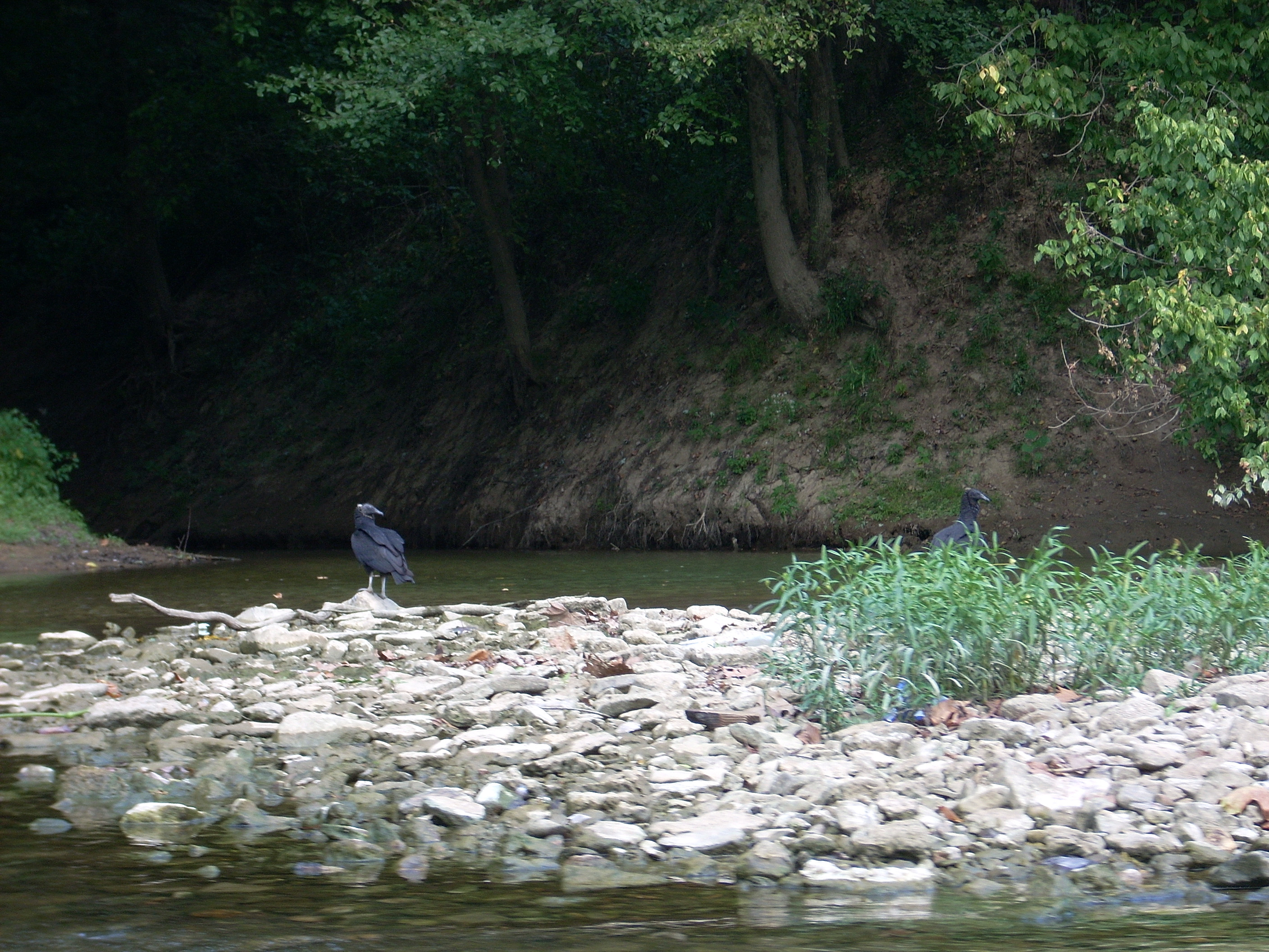
There were several turkey buzzards here that were not scared off by my presence. They were too intent on fishing it seems. Some of them do a peculiar thing: they’ll sit in a line atop a log looking down with their wings spread apart as if ready to take flight at the first sign of a fish. They do this so closely together though, that the crowding would seem to take away any advantage that this would gain.
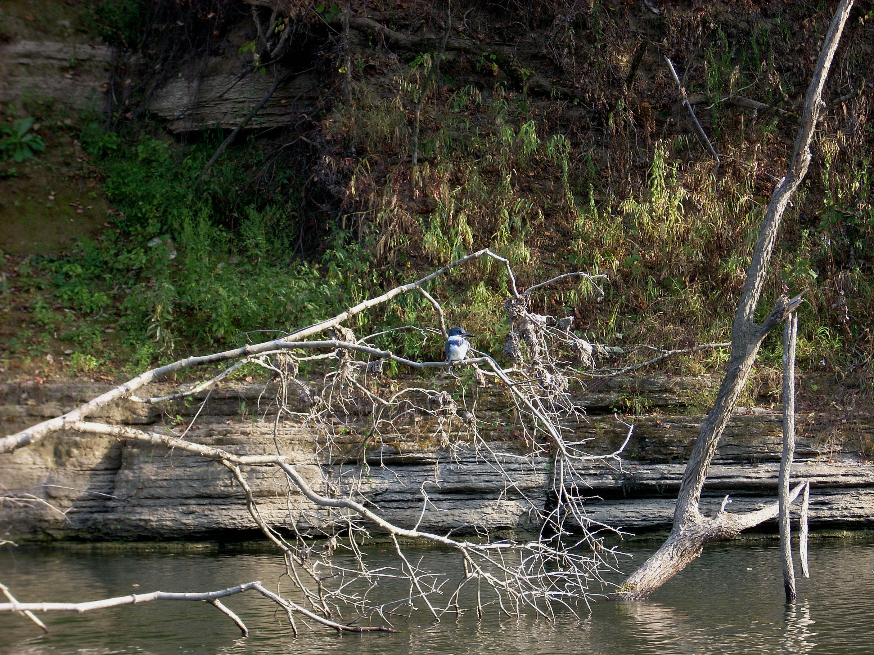
I saw another large bird on
the way back. Only it's long neck protruded above the water,
while the rest of it was submerged - kind of like some of the pictures I see of
Nessie (the Loch Ness Monster!). It was kind of funny.
When I got back
and headed out I took some more pictures of the area and I also
stopped to look at that bridge tunnel. There’s a short span of
dirt road immediately after the bridge ends, so I drove in. I was
really careful coming out though! There was very low visibility getting
back onto the road. The other side of the tunnel (you can’t
drive through it) is even easier to access. There’s a worn off spot on the
side of the road where many people must have stopped to look at it just as I
had. This is truly an amazing location!
DIRECTIONS:
Take US68 to the river. That’s the easy part. It gets a little
harder to describe after this because this city of
From the South:
If
you’re coming in from the south via US68 East from Harrodsburg, you’ll want to
turn right just before crossing the river. I didn’t see a sign, but this is
apparently
From the North:
If
you’re coming in from the north via US68 West from Wilmore or