.JPG)
2008 Kentucky River
Dam 8 to Mile 129
Sorry about the
somewhat nondescript name above for the end of this trip. You see, I
started out wanting to get to the Jessamine Creek closer to mile 127 but I ran
out of time. I woke up a bit later than usual and wasn’t able to get
everything in. I’ll pay for this the next time I come out as
I’ll have to make up a lot of ground. There are only
3 public access points in this pool, you see: one at mile 135 (
The put in I
used at
Anyway, the ramp I
would use today was the one for the Otter Outpost (upon updating in 2019
I'm not sure if this is still around). There were two different
ramps to choose from, actually. Both cost $5, and while every paddler I’ve
talked to thinks this a bit high, people do have to make a living and this is a
fantastically historic place as well as being near the heart of the palisades.
The area between miles 131 and 130 is especially nice! If you’re a
lover of the fall season, as I am, you can get a head start on it by coming out
here.
I paddled up to
lock and dam 8 where I ended the last time. I've been told that this
particular lock was the last to be made of all stone by Italian stonemasons and
it's physical
location from this downriver side looks almost exactly like that of dam 12 in
Here's a shot looking down the lock ladder...
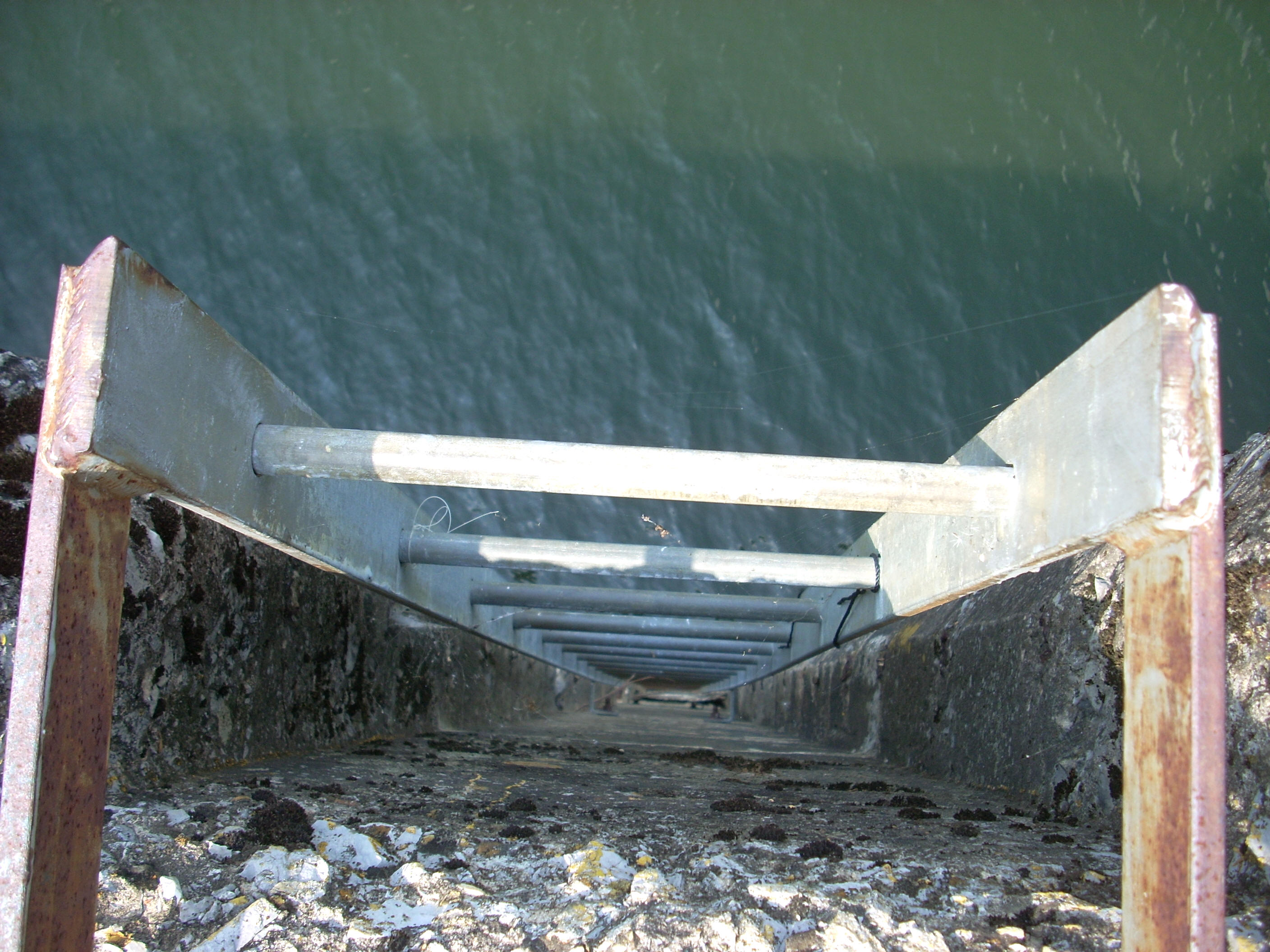
The lock gate...
.JPG)
There’s another
beach here on the
downriver lock side too (visible on the right in the picture below) which could rival the size of the one back at dam 10 in
Lock and dam 14
Lock and dam
13
Lock and dam 12
Irvine/Ravenna beach and campground
Lock and dam
11
Lock and dam 10
Already a Boonesborough/Winchester beach and campground
Lock and dam
9
Lock and dam
8 Nicholasville beach and campground
Lock and dam
7 Haven’t seen it yet, but a
perfect High Bridge/Wilmore beach and
Lock and dam
6 Harrodsburg beach and campground?
Lock and dam
5 Versailles/Lawrenceburg beach and
campground?
Lock and dam
4
Lock and dam
3
Lock and dam
2
Lock and dam
1
.JPG)
Given the above scenario, the entire middle of the state
could have a beach nearby! There's much more to it than this, but I look at it this way:
the more awareness that can be brought to the river, the more likely this
will become. More awareness might engender more of an aversion to pollute
the river. At the same time
the communities, to include both government and private enterprise, could get
more involved in coming up with better environmental alternatives so that
certain kinds of pollution need no longer be an option - government
could provide the incentives and private enterprise could provide the solutions.
The environment would then be given a better opportunity to cleanse itself naturally, and the
resulting cleaner water would enable people to swim in it again without fear of
bacteria. This could, in turn, drive revenue back to the 3 groups which
helped make it possible: communities, government,
and private enterprise! Oh, how I’d love to see this
happen!!!! Am I a hopeless dreamer? Sure, but it sure is sweet to
think about!
Enough of my musings! There was a warehouse in the early 1800’s immediately down from dam 8 which was called the Liberty Warehouse, and it served the tobacco farmers between the warehouses at Quantico Landing (in the upriver pool) and Hickman Creek. You'll find an orange marker here where this warehouse used to be. The marker corresponds to the historical narrative in the Jessamine County Kentucky River Task Force Guidebook that I keep mentioning… Wait a minute... This was strange… The guidebook covered the area between dams 6 through 9, yet I hadn’t seen any markers in the last pool. Odd… They must have been vandalized or stolen, yet I would see several on the trip today.
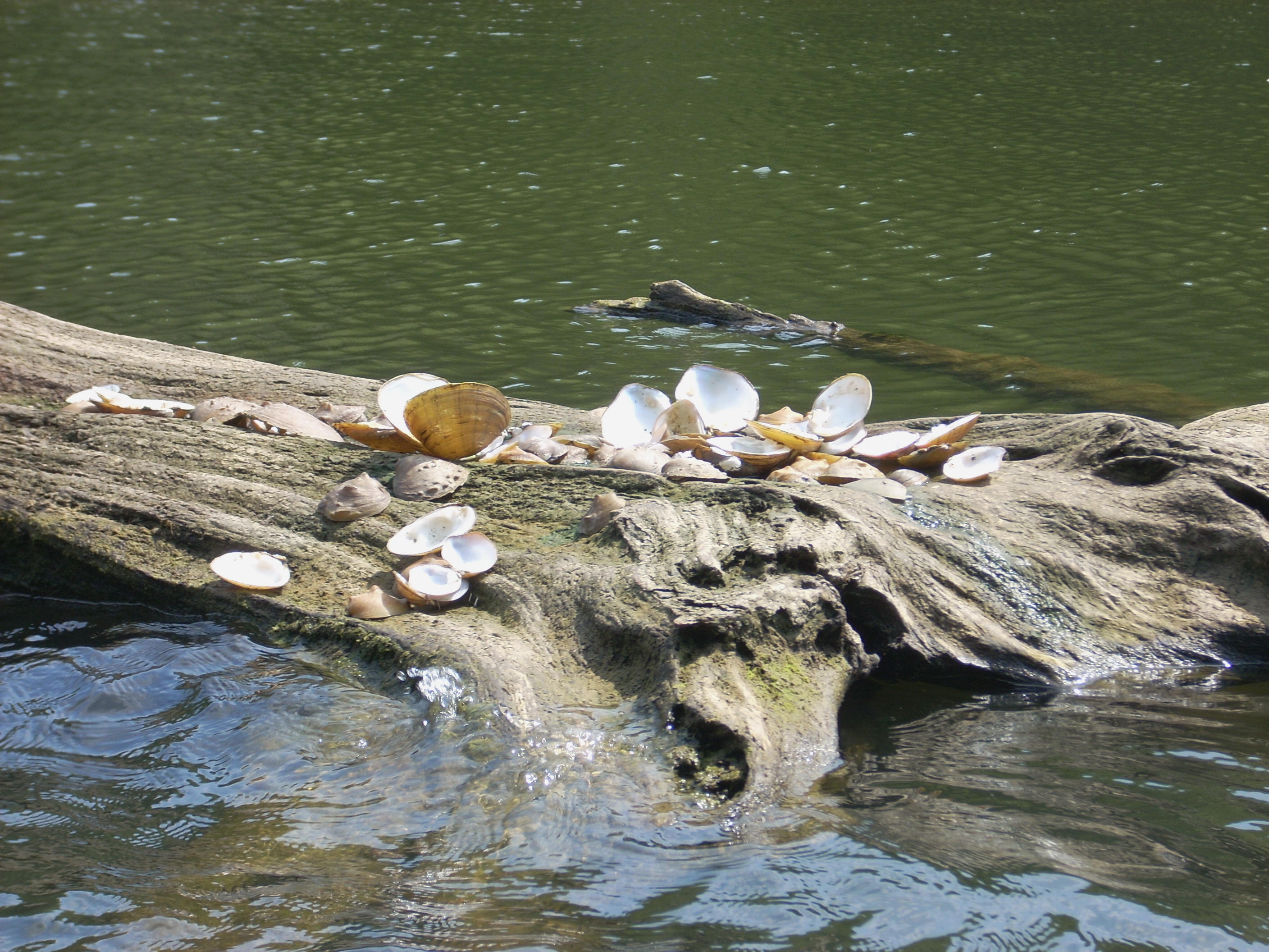
I noticed here too, the remains of “someones” lunch - that someone being an animal of some kind! There were a lot of large shells lying on the dead trees in the water with the mussels eaten from them. I wondered what kind of animal did this? Whatever kind, it must have been pretty strong to pry open the shells. I’ve heard that shellfish can exert an absolutely amazing amount of pressure in keeping their shells closed to predators.
After the beach
on the right side, that bank will turn rocky at the start of a curve left in the
river. It'll be forested on the right bank. There really isn’t much
farmland in this stretch - at least not that’s visible. One side is rocky
with or without a palisade and the other is forested. The exceptions to this are
at the dam
and at
Anyway,
when you get to mile 138.5 you’ll be entering what’s known as the Devils Elbow. The shape of this area looked more like a tooth (molar) to me than an elbow, but this tooth is said to have chewed up a lot of log rafts in the old days! To understand this, you have to understand how things used to be on the river before the dams were built. From the 3 forks in Beattyville all the way down the river people would construct rafts along the shoreline that they would stock with all kinds of wares – anything which might sell downriver, be that in Frankfort or in New Orleans! These boats or rafts could weigh in the tons, and the men who were to be the crew would wait until the early spring rains came before there was enough water in the river for their rafts to float downstream…
Well, just as
soon as the river was high enough to lift the rafts from the shoreline, off they
went. These guys would be away from their wives and families for months if
they were going all the way to
Imagine having to unload a ton of freight in order to float your raft off the bar and then reload it again, while at the same time keeping it from floating downriver while you're at it! Quickly too man! You don’t want the others to gain an advantage by beating you down the river! You’re now even colder, wetter and more fatigued than you were previously (you’re probably in a vicious mood by now too) and you could potentially be doing all this only to get stuck again at the next curve! It could be enough to drive a man insane! Thus, the name Devil’s Elbow! Rafts and cargo, both intact and in pieces, must have really piled up here at times making for quite a chaotic scene!
.JPG)
Ugh! I
think it's best to get back to the present now! It was a LOT more
tranquil here today (as you can see from the picture above. Even the
aforementioned sand bars looked pretty innocent! Dry Run
(heard that name before!) comes in - dry - at the mile 138 curve and Canoe
Creek comes in just after it over a large, rocky shoal. This shoal was, in
fact, almost an island which I came very close to paddling around today.
Canoe Creek Bar (the sandy kind!) is across the way.
At the mile 137 curve the rocky bank will switch to the left, and on the right at this point is where the navigation charts indicate First Vineyard used to be. I suppose it could have been here, too, but the boating guide had this location as being in the last pool. Maybe I’ll be able to reconcile the two versions sometime... [I've actually been able to get some clarification on this since I wrote this journal. According to George Dean of Jessamine County, the spot was actually above dam 8 on a hillside near the Sugar Creek Ferry landing across the river from where the Quantico Warehouse used to be. Thank you Mr. Dean.]
Anyway, on my way up to
the dam I'd noticed quite a bit of wildlife in this area. I was just able
to spot a turtle (which looked to be of the box variety) emerging from the
depths at the middle of the river to stick it's nose above water. It
darted back down as soon as it noticed me (maybe the bubbles I see coming to the
surface all the time are from turtles at the bottom of the river?). I took a little movie of the gar
here too with my camera. They were “fishing” for
minnows. I hadn’t noticed any of them in the last pool, but
the minnows were now visible in giant waves and the gar seemed to
split them up and go after them individually. You could hear the gentle
“sklorp” and “plop” sounds as they popped up just over the water to snatch the
little minnows which swam near the surface.
At mile 136 a
palisade will come in briefly on the right side just before Little Hickman Creek
enters at the curve left (lots of fairly sharp curves here, but they’ll lengthen
shortly). There’s another large shoal with a gravel road coming down
onto it, and here there’s another SWEET looking cabin just up the bank.
This ushers in a series of dwellings on this side, and on the opposite side
you'll find the road I described that winds down to reach the put in at
By the time you
reach Hickman Creek at mile 135.5, you'll have dwellings on both sides with the US27 Bridge
visible in the distance. As mentioned before, this general
area was the site of the
Meanwhile, just
downriver from Hickman Creek on the same right side is something called Boone’s Knoll.
The first steamboat to travel from
As regards the
.JPG)
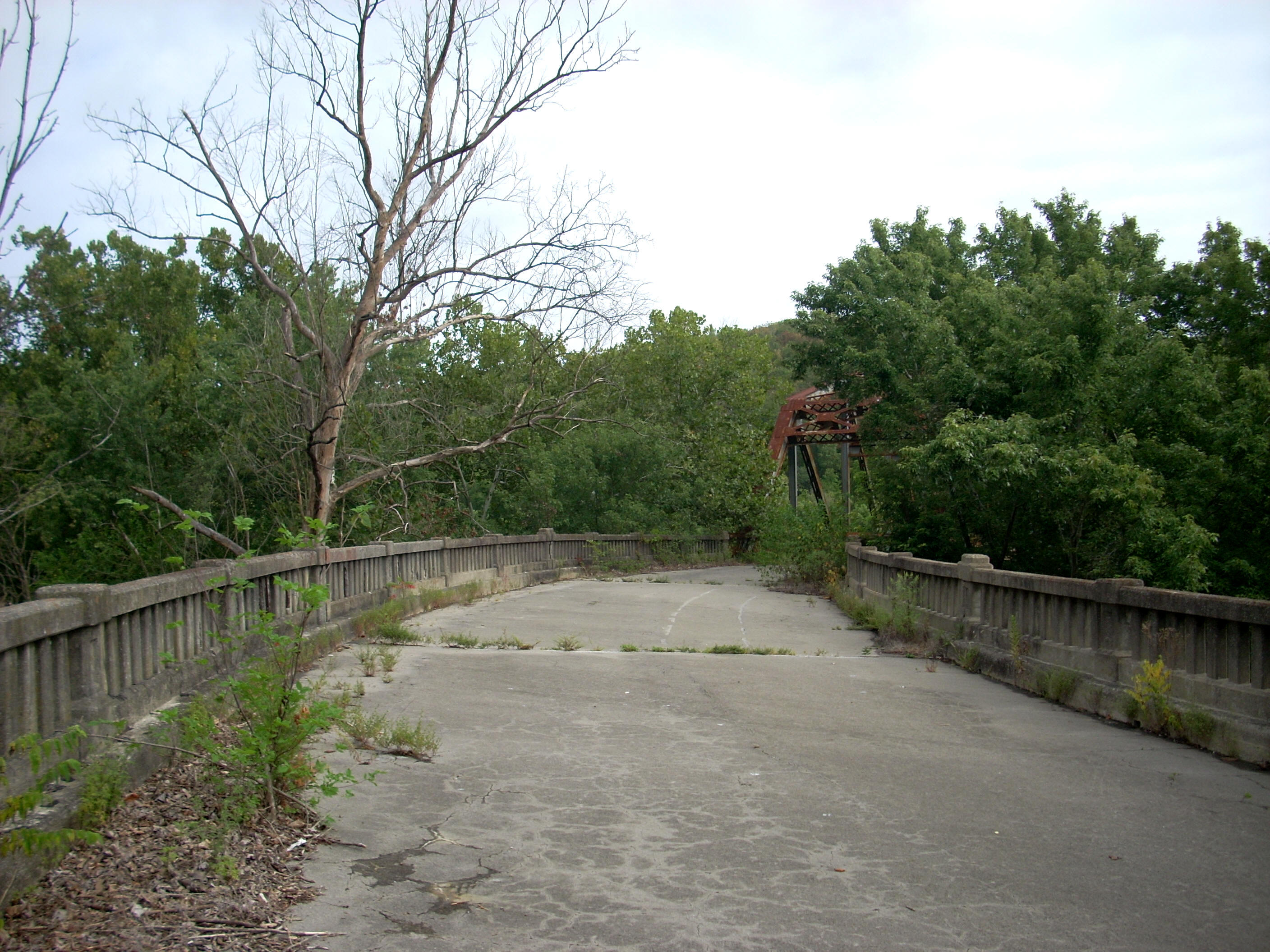
So, too, does the steel truss bridge which still spans the river here. Its roadbed is still intact too, but it’s blocked off. I’m going to look into approaching this bridge from the other side of the river sometime to get that perspective as well.
Immediately down from these bridges there’s an old intake for a former distillery on the right (some of it's warehouses are still standing way atop the banks out of sight but you can see them if you drive in from Nicholasville). Meanwhile, the Camp Nelson Boat Dock and Campground is on your left, and if you look downriver from this spot you’ll see rocky palisades in full splendor on either side of the river. They’ll tease you, coming in on one side and then the other as the river meanders through them.
.JPG)
.JPG)
You’re entering into a long “C” curve at mile 134.5, and from this point on the palisades will be constant companions. You’ll be able to see them at every point. If they’re not visible right alongside you then they’ll be visible in the distance or through the trees. They made me feel small and insignificant and even though the wildness of this river has been tamed by the lock and dams, these palisades provided testament as to the power and grandeur of this underappreciated river.
The palisade on the right along mile 134 reminded me a lot of the one which contained the Devil’s Pulpit back in the last pool, and the White Oak Creek came in from the left just before mile 133 over another large shoal. This creek was several feet wide, and the shoal was another that quite nearly formed an island. Incidentally, the Tom Dorman Nature Preserve is atop the bank here and you can apparently take a 2 mile hike on the grounds to overlook this point.
As for the palisades, they'll now start to become more noticeable on your left side as they stretch for another couple miles. Markers on the right warned me to keep out (and I would!) but I didn’t really notice them too much because I was gaping so much at the beautiful palisades.
.JPG)
When you get to mile 131.5 look closely on the left for the Candle Stick rock formation. It’s free standing and it has it's own marker down by the water (look for the orange). There’s a picture of it in the boating guide and in that picture there are guys standing under it and on top of it! It must have taken quite an effort to get up there! The rock looks pretty precarious and they couldn’t have known whether or not it would topple right down on them as they were climbing up. Who says there weren’t any daredevils back in the 18 and 1900’s?!? This is the formation right in the middle of the picture below with a little bush on the very top edge.
.JPG)
Right after
this formation the palisades will switch back to the right again and, even
though it was still August, it looked like fall here. It was absolutely
glorious with the palisade and all the color!
Here at mile 130 on this right side was another historical marker. The
.JPG)
I got a little
confused at this point. The navigation charts indicated that there were
either 2 rock formations, 2 caves or a combination of the two in here - Swallow Rock and the
.JPG)
I made it to
about mile 129, and I’ll describe the spot as best I can. It was at a
seeming break point between the palisades on the right – a point where the rocks
at the very bottom of the bank had given way to a muddy/sandy bank - and on the
left side was a spot where several cow paths had converged at the river. I
was a bit dismayed that I had not made it quite to Jessamine Creek but hey, as
my Uncle puts it: “Into each life a little rain must fall!”
All the way on this trip I'd noticed that the buzzing insects had gotten more aggressive. Even when I was out in the very center of the river they buzzed around me. I imagined some to be flies, but it was still a bit disconcerting not knowing for sure whether or not I’d get stung. I really nailed one, in particular, a couple times with my paddle - unintentionally. I'm pretty sure this one was a fly, but I felt it and I heard the “bap!” when it hit. One was a bee, however. I annoyed it somehow and was just able to duck my hand into the water before it stung me. I then drenched myself (bees supposedly don’t like water even though we're on a river!). It occurs to me that fellow drivers can be like bees. Irritate them, even unintentionally, and they’ll risk their lives and yours to "teach you a lesson". For what? To defend their right to be rude and maybe gain a few seconds of time? I'm tormented by the hatred I see on the road.
When I got back to the ramp I had another dog barking at
me. Great! I didn’t have a problem here, but this was getting
annoying. It seemed that I was encountering a dog at every ramp. The
dog was the only sign of life, though, and I hoped that the Otter Outpost would
get some business over the Labor Day weekend so that people could see all this!
DIRECTIONS:
Access to this ramp is right near the US27 Bridge going across the river at the
top of the southern hill. If you’re coming from the north, it’s the first
left after you cross. If you’re coming from the south it’s the last right
before the bridge. Unfortunately, the road sign (