Monday, August 12, 2008
Dam 11 to the Red River (Mile 191)
I think I’ve mentioned it before, but when I’m revisiting points on the river that I’ve not paddled for a while the feeling is somewhat similar to visiting an old friend. I’ve put in from the ramp at the end of KY977 three times now - once last year, once this spring and today. This well paved ramp is right across from where the
Anyway, for this stretch of
the river you'll find a rocky bank on one or the other shoreline almost the
entire way. That bank will take on one or more characteristics: rocky
shoreline, rocky ledge, rocky overhang or cliff. This area will thus make up for the last 2
pools in terms of having places to stop and rest because even where there
aren’t rocks there’s often a sandy beach.
.JPG)
When I arrived here last year, I’d noticed some boaters using a ramp on the lock side almost immediately downriver. I thought at the time that this ramp might be private, and after having gotten out and checked today, I do still believe this to be the case. In fact, it looks like this might be on someone’s farm, so I beat a hasty retreat back down and headed to the very corner of the lock to check out the portage feasibility… Here you’d have to walk up roughly 30-40 feet to the top over vegetation and large slabs of rock and concrete. Apparently some old ruins were left discarded here.
.JPG)
.JPG)
Having seen this, I crossed
to the other side of the river and in doing so I noticed a very large tree suspended
partially over the dam. I mentioned in the last (upriver) journal that
this is a great spot and the shoreline on this dam side of the river is especially
nice. It’s a bit trash strewn now, but what an awesome recreation area
this could be! There’s a picturesque rocky ledge along with a sandy beach
where I found quite a few
white shells visible under the water (mussels?).
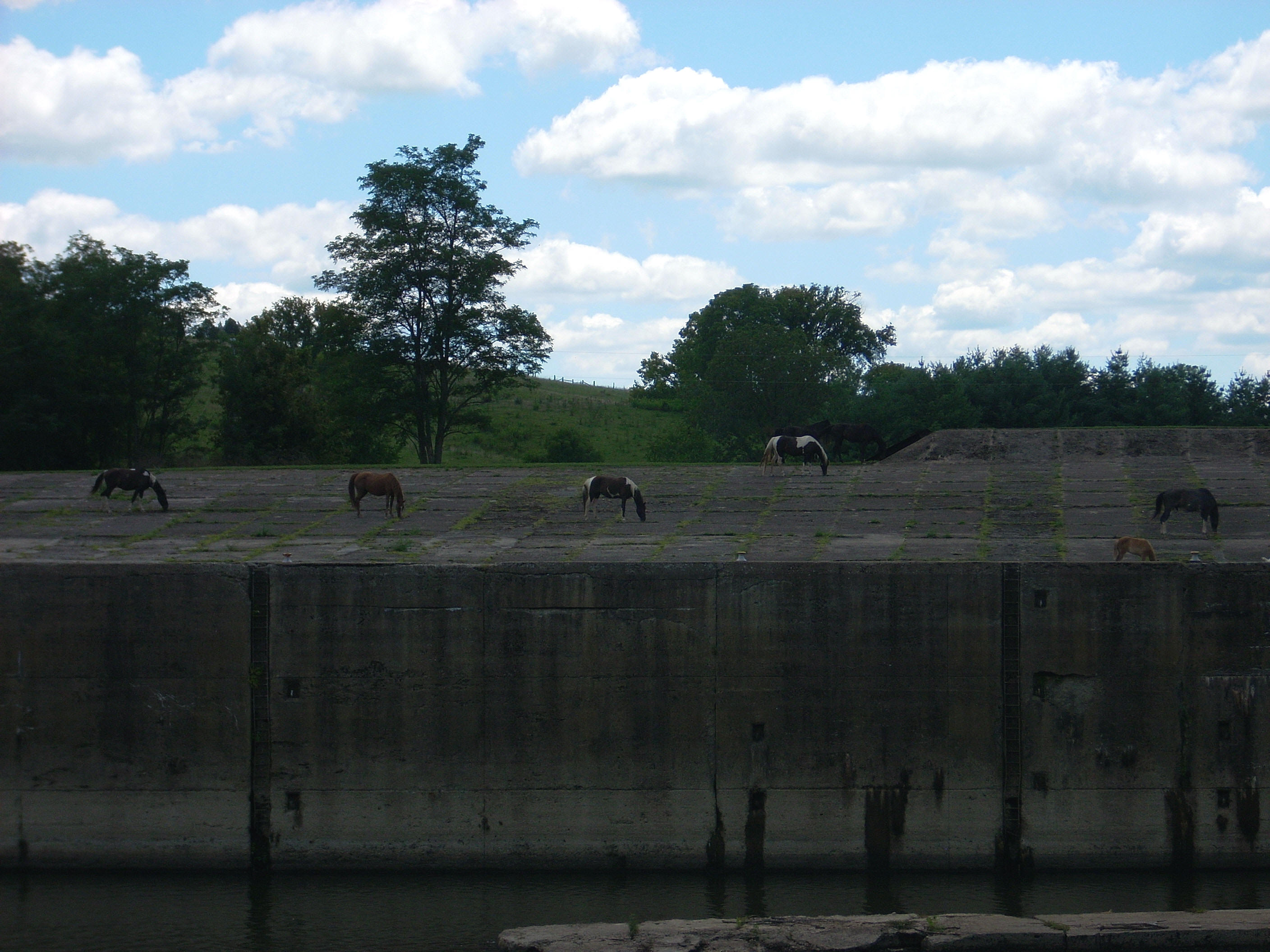
When I walked up on the beach to take some pictures I got a chuckle. There were actually some horses grazing across the way on top of the lock! There couldn’t have been much grass over there between the concrete, but there they were - about a half dozen of them! This was something else that made me want to just throw up my hands and laugh! What a great sight! I climbed as far up the rocks above the beach as I could, but was unable to get high enough to get a good, all encompassing view.
Departing from the lock and
dam I launched into today’s first shape – a slide. I’d be going up the
slide in this case from right to left. The rocky shoreline switches sides
from the left to the right bank of the river at the bottom of the slide and it
continues this way all the way up (from the dam to about mile 199).
Lick Run
comes in from the right over a shoal in here, but it was quite shallow today. On the other side,
however, was
some of the nicest looking rolling farmland I couldn’t see yet. :) It was only
partially visible from down on the water.
.JPG)
The only paddle-able stream on
this trip would come up next - the Noland Creek. It comes in just as you get to the top
landing of this slide. I got in about 50 yards. There was a nice house
at the mouth of this with an interesting camping and fishing setup down on the
bank. Following Noland, there’s a string of several rocky
shoals on the right through which the Raven Branch (only a couple feet wide
today) enters.
Back to my slide shape - as you go down the ladder the scenery shifts. The rocky side is on the left now with the farmland on the right and a few things interested me in this section. As per the picture below, some of the rock overhangs look almost like the planters you’d see on a window ledge. Also at a few points you’ll see a kind of alley all the way down the mountain where a little unnamed stream has come down and taken out everything but the rock face. There was also a fallen tree protruding up from the water at one point in here that a considerate boater had painted bright orange in order to make it stand out. People on the river almost always seem to be very considerate.
.JPG)
After the slide another shape
takes form. As you turn to the next page in the charts and face it in the
direction that you’re going you’ll see the silhouette of an ear!
This ear will be in the position of a person lying down on their left side, and
the river will follow this outline from the top of the ear all the way back to
the ramp at the base of the “neck”. The ear itself covers mile 197 to 192
while the neck comes in from mile 192 to 191.
The shorelines will alternate
scenery again in this area (rocky bank, farmland bank) and between mile 196 and
197 in particular there looked to be some really nice cattle grazing land.
This acreage was complete with shade trees along the shoreline that the cows
could cool off under. It was apparently feeding time for some of them here
as they were heading out, mooing all the way. I heard a donkey braying in
the distance too. Cow Run comes in at mile 196
but was not navigable.
There’s another house in a
clearing on top of a mountain just after this, and at around mile 195 there’s a
cabin on a steep and rocky mountain slope. Every time I come through here
I wonder how they were able to construct it. It must have taken a great
deal of time and work. Just getting the
materials to this spot must have been an effort! On the other side, at around
mile 194, there was another wooden structure down by the water which I hadn’t
seen before. It looked like part of another camping/fishing setup and it
was quite clever.
I’ll note here that it continues to interest me how perfectly the scenery shifts on the river. In looking at the map now, it seems that the rocky areas are on the outside of each turn in this area, and this was the case as I continued on past Thronburg Bend at mile 193 and into Strawberry Bend at mile 192. I also noticed something in this area that I hadn’t noticed before – how the sunlight shimmers across the tree trunks! It almost seems to shatter and dance all over them while in others it moves in waves as it shimmers - quite an interesting phenomenon.
“Devil’s Backbone” is the name given to the rocky shoreline from mile 192 to 191 which, on my crazy silhouette, stretches down the back of the neck below the ear. The
On a side note, I got a
picture of a couple calves checking me out on the way upriver. I think
it’s a good picture although it’s a little blurred. It reminded me of a
good family friend of ours who paints pictures of farm scenes. I had
forgotten this, and when I checked out her website I was quite impressed.
I honestly think anyone would be. I can now say that Mrs. Leach is not
only a great person, but a great artist as well! You can check out her
site for yourself too, if interested, at
www.margiekleach.com.
DIRECTIONS:
KY52 to KY 977 (only 1 way to go) in