PLACES TO GO ON LAND HOME PLACES TO GO ON WATER
Laurel River Lake
Tuesday June 17, 2008
Having hiked the part of the Sheltowee Trace trail that meanders around this lake last Wednesday I couldn't help but notice how beautiful this lake was with its turquoise water and inviting rocky beaches. I decided then that I would definately have to kayak this lake and that I would do it this week.
Also
factoring into this decision was the fact that it gets a little tricky hiking
this time of year. On my hike out here I had a problem with ticks and that
was part of the reason I've decided to pass on hiking -at least until the fall.
I started out this trip a little after
It was quickly apparent that
my first impression of this lake from the trails was correct and that it was
even better being right down on it in a kayak. It seems that every inch of
shoreline is one continuous beach and it's easy to get out and enjoy a quick
break or a dip in the water. The lake bottom does seems to drop several feet
from the shoreline though because the water seems really clear up to a point and
then you lose visibility fairly abruptly. There is very little trash if
any.
There were quite a few power boats and jetskis out but they were all very courteous to me while I was out there; but if you wanted more privacy, there are several coves in which tree graveyards prohibit anything but a kayak from entering. All the coves are great and they're very clean despite too despite the fact that there are large campgrounds out here (I note this as I passed White Oak Campground) which in some areas cover most of the shoreline. Each of these seems to have an individual entrance path down to the lake which is kind of nice. It allows each camping party a bit of privacy too.
This would be a fantastic
place to camp! As a paddler though, it was nice on a Wednesday because
there weren't many campers out there. I could stop paddling and just
listen and take in the sounds of nature around me without interruption.
All of the shoreline up to
this point had several feet of beach followed by forested hills. As I
rounded the bend that took me into the Cane Branch Cove, however, I noticed
something different - a large grassy patch. I couldn't get to it though.
My way was blocked by a line of orange bouys that stretched all the way across
the lake and cut of most of the cove. I assumed this was to keep boats
out, although they might allow kayaks and canoes - I don't know. Either
way I was a little disappointed as I moved on.
Presently I rounded a bend which took me into the Craigs Creek Branch Cove. In this area there didn't seem to be any campgrounds so there was more wildlife to see. I noticed a blue heron in one of the unnamed little coves as well as some fish and a huge spider crawling along a boulder which had fallen in the water.
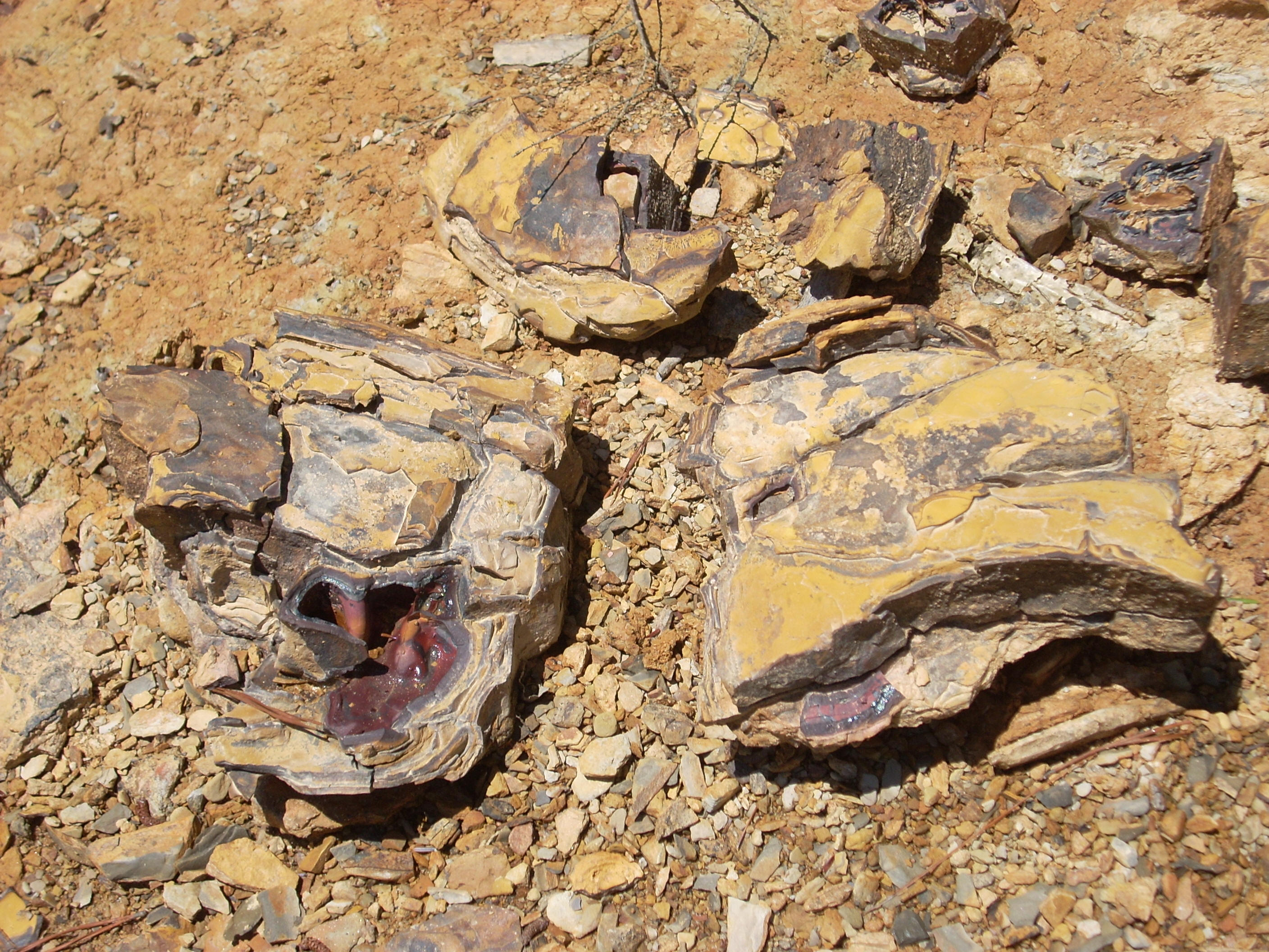
I also saw a large beaver dam and it was near that point that I made my first stop to take a dip in the water. It was warm along the shore and quite inviting. I noticed some of the rocks as I did so. Some of them look like rusted pieces of metal they are so full of mineral content. It's quite interesting.
After my break I encountered 2 very nice people on jetskis who had come up to take a break on the beach after I came out of the cove. I told them that this was my first time out on this lake and they asked me where I came from and where I was headed.
According to them I hadn't seen anything yet - the best was yet to come. They told me that there were cliffs just around the bend and that people have been known to dive from them! There were also some underground caves which people explore in scuba gear as well!
I was immediately intrigued
by this because I do a bit of caving and the thought of exploring underground
caves is one that I will have to keep in mind for the future. I'd have to
learn to scuba dive though.
Anyway, it turned out that they didn't steer me wrong! There were still beaches at this point but they were interrupted by rocky cliffs with neat rock formations. That said, this area did seem to be the most popular spot yet for power boats and I had to avoid exploring some of the nooks so as not to interrupt the peace and privacy of these boaters.
I always try to be conscious and respectful of others though it's not really in vogue to do so these days. I'm still a bit unsure of the etiquette on this point though. I want to be friendly and say "hi" and/or wave to boaters: but if someone is fishing I'm afraid I'll scare the fish from them if I do. Thus, I've adopted a policy of not speaking unless spoken to. I just think this is the most courteous thing to do although I'd be interested to hear from any boats or fishermen who might inform me otherwise.
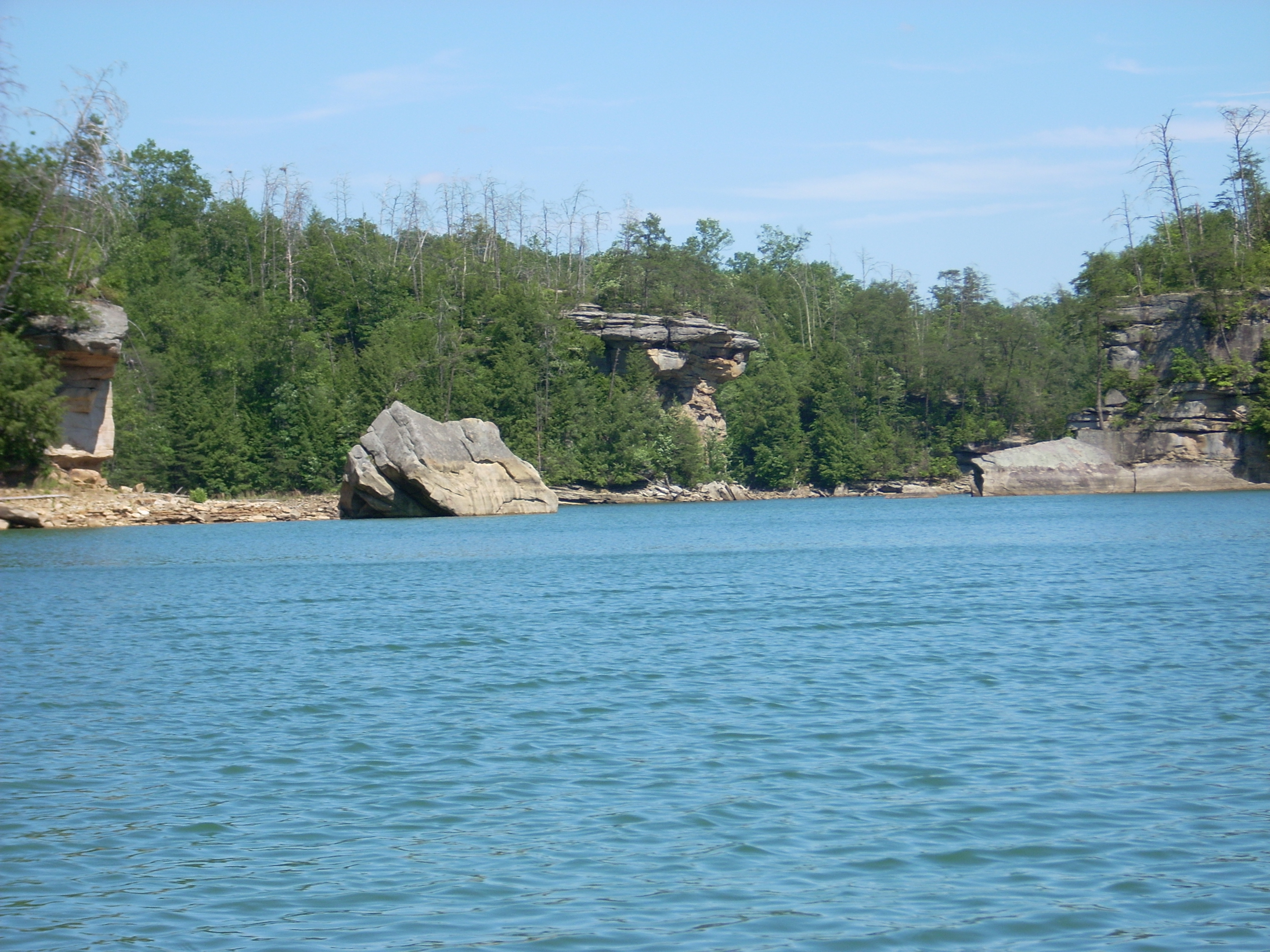
Judging from the map I cut off quite a bit of Craig's Creek Cove, but I do plan to return to paddle more of the shoreline from a different put-in point. As I did paddle through here though, I tried to imagine exactly which cliff the people dove from and which rock formation had the underwater caves. There are a number of possibilities.
As I came out on the other
side I waved at the jetskiers who were still beaching across the lake.
They'd been very kind to tell me about the lake and they seemed very
enthusiastic in doing so. In fact, everyone I talked to today seems to
absolutely love it out here - now I do too! (Why is it that boaters are
all courteous and drivers are all "bleeps"? Maybe it's the relative
tranquility.)
I decided to head back before
starting the Indian Camp Creek Cove because it was around 5 at that point and I
usually like to get back before dark. When I did back though I realized
that I could have gone another hour or so! Next time I'll start much earlier,
because I will definately be out here again soon!
DIRECTIONS
I75 to exit 38 (KY192). Go west about 10 miles, and once you pass the Bald Rock Picnic Area on the right, begin keeping a sharp lookout for the Marsh Branch Boat Ramp sign. It’ll come up quickly and you’ll have to turn. The sign will be on the right, but the road will enter from the left. This is forest service road 774. The ramp is at the end of this road.