
Kings Mills
Yes, the Lord must have a sense of humor!
Surely it’s a Scottish terrier that I see when I look at the contours of the
river I paddled today! (OK - maybe it’s a slightly
humped back terrier, but it’s definitely a terrier looking to its left!)
I began this trip from the tip of the tail at the Bryant’s
I took a right from the ramp
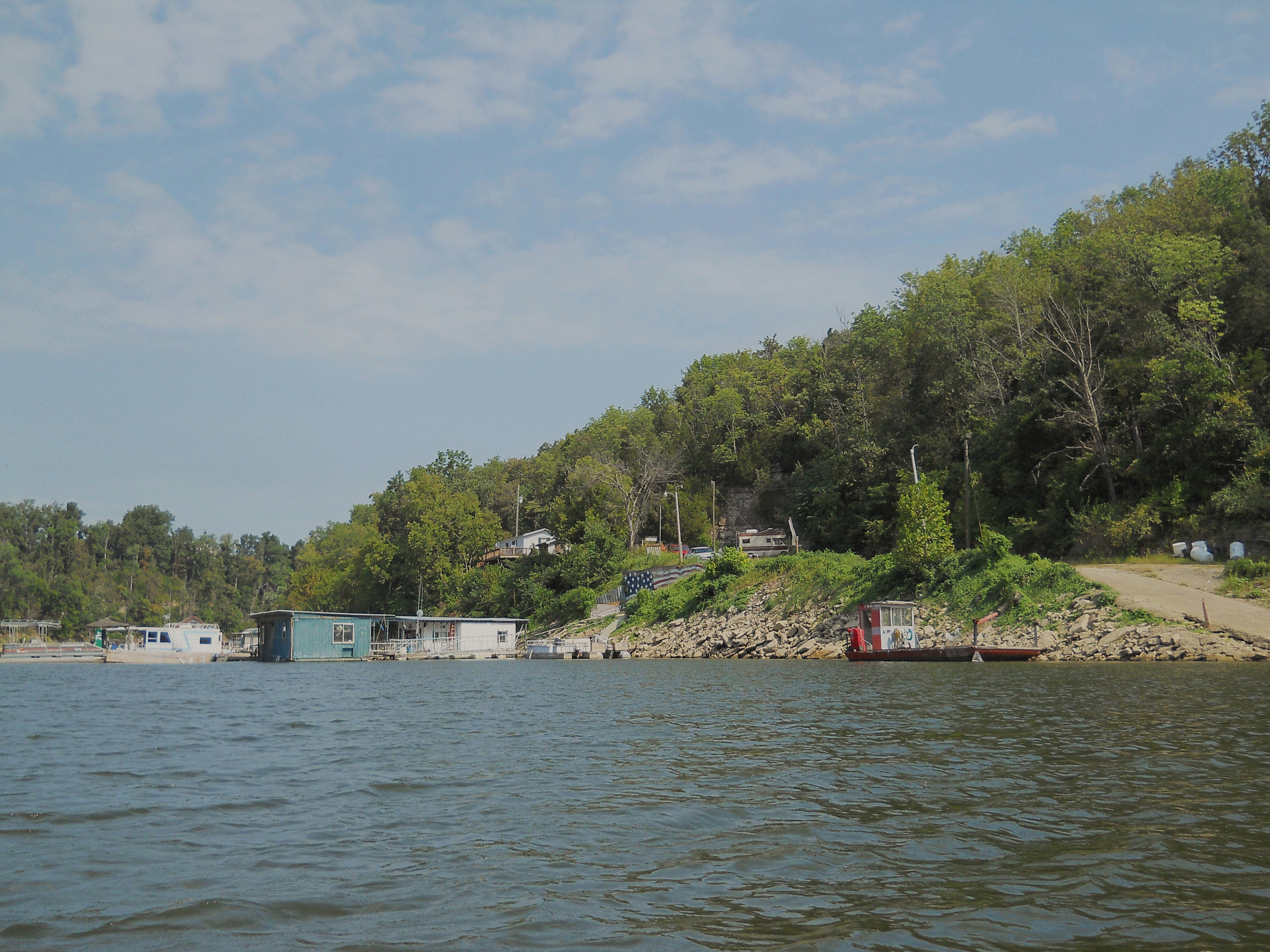
once I got on the water and headed downriver (or lake) to the Kings Mill Marina,
finding it to be of great interest too. In fact, I think it –
like the business described above – is a testament to something. In this
case, the American spirit! Kings Mill had recently been washed out by
the spring floods, you see, and I understand that a lot of it had
broken off and drifted downstream. I’m not exactly sure how
much, but I do know that the damage was pretty significant. Well, as I sat
looking at it today with the American flag painted on the rocks in the
background I noted how the good the place looked after all that mayhem and I couldn't help but feel the American spirit at work! Kudos Kings Mill!
I’ll begin describing the
paddle today as if I’d started from this point and then headed upriver.
That’s how I’ve done it in previous entries for the area... So, after turning
around I first passed under the KY34 Bridge on a sharp right curve before
launching into a very slow left arc. In this section you’ll notice plenty of houses atop
little cliffs - cliffs which often end at the water in a little set of stone
“steps” (this area of the Dix is, in general, pretty home-lined and some are
quite impressive).
Another bridge – the Old Kentucky 34 Bridge – crosses the water here too, yet I was frustrated as I tried in vain to get good close-up pictures of the wildlife. This new camera I have is supposed to be an improvement over the 4 year old version I had previously, but I’m not so sure yet… In fact, I may switch back to the old one! Then again... I guess this did turn out OK, but darn it, is this a loon or a grebe or something else entirely?!?

Soon the houses on the right will seem to disappear and there will be
a shoal on the left. The ramp I used (Bryant’s Camp) runs over this shoal, and
an incoming stream (
The water at this point still seemed to be at a fairly good level and the shorelines at a fairly good width, so I thought I might be able to get a bit further back and leave these people in peace for a while before paddling back out... It wasn’t to be. Just my luck, after rounding the very next curve my progress was stopped by low water and rocks! This cove was beautiful, though! Check out the rocks on the one side and the gentle slope of the shoreline on the other…

Once you get back to the Dix River/Herrington Lake, you'll be heading upstream along a little straight which composes the tail of this dog shape I mentioned. Just past the Bryant's Camp ramp on the left I found an interesting structure extending out from the rocks. It looks like it might have been an old water intake or something, but it’s really well - and classically - constructed! There was a tiny cove in this section too. It didn’t go back far at all, but I noticed a ton of little yellow moths on the muddy shoreline…

…and coming out, I got a decent heron shot…

The tip of a right curve
will soon deposit you onto the dog's back and there’s a little gravel ramp here which
looks private. You'll next find yourself along
another straight, followed by a short left curve and then a long, slow
right curve. The outsides of these bends consist of fairly tall forested banks that end in rocky ledges
at the shorelines. The insides are low lying, grassy, and home lined.
They’re very nice spots.
Many more ramps enter in this area. There’s a neighborhood one off of Herrington Haven Road and then there are 5 more along Clifton Road. According to the Fish and Wildlife map, one of these is/was for Miller’s Landing, but I thought the ramp below was the most interesting. There appears to be some kind of pipeline that goes over the water here and the ramp itself appears to be gravel while some lamp posts provide lighting. It’s really a very nice spot.

From this point on the signs of habitation will be fewer and farther between in the midst of farmland. There will also be a sheer rock wall on your right side at one point…

After making a left curve you’ll begin a long, slow right one that will take you down past the dogs’ eye socket to the tip of its snout. Here, about where you’d balance a dog biscuit (if you were really mean!) were some great grassy areas that looked to be part of the property of some very fortunate people! Here I saw a couple turkey vultures along with a large school shad minnows. It really is a lush and beautiful environment.

There’s a fairly sharp left
curve now to complete the muzzle of the dog, and near the end was another ramp
on the left side that was so nice looking I’ve got to assume it was a private
neighborhood ramp - but I’m not totally sure. There was more
farmland across the way from it, and on the map it appears that this land is all part of
another large farm which comprises the entire inside of the next right curve.
Here I met with a great sight too. The farmer had a great fishing spot set up, access to which was attained on a
path through his fields. It was a classic rural scene!
This last area was all farmland all the time and it was extremely quiet and pleasant,
yet I wouldn’t get much further - the water quickly got really low and rocky
just like it had in the little creek across from the ramp. Alas, my hope
of making it to the Hanging Fork of the

The rural scenes on the right
in here were exceptional though, and I wanted to get even more pictures but the
memory in my camera ran out! Seems I hadn’t adjusted for the fact that the
higher resolution on this new camera would take up more memory... Oh,
well.
I’ll make a general note here
and point out that there is one good thing about paying at a
ramp – it’s likely to be safer. Not only do you have the peace of mind in
knowing that someone is there, you also know that the mere presence of that
person is likely to discourage misbehavior. So, keeping this in mind, I
found myself free to stay out a little later than usual. In fact, I
floated quite a bit on the way back in order to better take everything in.
If I hadn’t I might not have experienced the funny occurrence that I did.
I saw a fisherman onshore at
the inside of a curve, you see, so I cut the boat to make a long arc
around him so as not to disturb either his line or the fish that might be
interested in his bait. Well, once I’d done this I saw the “fisherman” in
full view. He was part deer, part gossamer! I’d only seen the front
of the deer, mistaking it for part of a human silhouette, and the fishing “line”
I saw angling into the water was apparently one large strand of a spiders’ web!
DIRECTIONS:
This ramp can be accessed off of US27 between
You’ll be on Bryant Camp for
a little more than 4 miles before you’ll arrive at the ramp. Stay straight
until you get to the intersection with Herrington Hvn and then make a right to
stay on Bryant Camp until it “T”s. Then make a left and go to the end of
the road. The ramp is here. It costs $6 and you can drop the money
in the mailbox of the old motel office.