HIKING
HOME
PADDLING
Big South Fork of
Cumberland River
Friday, September 19, 2008
Blue Heron to Alum Ford
Sheltowee Trace
River Resort website
The Sheltowee Trace River
Resort is
located near
Cumberland
Falls. Among other outdoor activities,
they facilitate moderate level paddling trips of different lengths on the
Cumberland River from a few different put-in's. The southernmost point is
called Blue Heron, which is the site of an incredibly interesting old mining camp
(website
here). The next is Yamacraw (4.8 miles
downriver from Blue Heron) followed by Alum Ford (7.4 miles down) and finally KY927 near Nevelsville,
Kentucky (11.5 miles away).
Today I was to meet a
representative from the outfitter at
8am and, difficult as
it was to wake up at 4:30 to allow for driving time from Lexington, it would
turn out that I'd need
all that time and more. You see, the
online directions I used were fine up to a point and then they were just totally off.
Luckily I had another map. With that and a little luck I made it to
the meeting point a tad after 8 (for anyone coming out I’d
just take US27 all the way into the
Whitley
City area
instead of trying to get too fancy). Whichever way you come
please watch out for stray dogs, wild turkeys and a possible horse on the road!
I came perilously close to a horse grazing right by the side as I drove down KY927!
Another thing to note about this area is
that it’s really remote. You likely won’t get phone service
out here, so your planning has to be flawless. This in mind,
I must have misunderstood the person I’d talked to the previous day.
I was sure they'd said that all the trips meet at the end of KY927.
While this did seem strange (because I'd started at Alum Ford last year) I
went on ahead to KY927 figuring that things do have a tendency to change…
Sure enough, however, when I
arrived there was a mini-bus with 4 to 5 passengers making a separate, longer trip. I was told by the driver that I was in the wrong place.
I should have been at Alum Ford! In fact, there was another driver waiting there just
for me!!! My heart sank... I could have
paid more and gone ahead with the driver here to do a longer trip (Blue Heron to
this point instead of just to Alum Ford) but I didn’t want the other
person to have made a trip for nothing. Would they still
be waiting there when I arrived though? I was ½ hour away!
The one driver tried to hail the other via radio but couldn’t get throug
h.
I was mortified.
Well, once having driven to
Alum Ford I found a really nice girl there who seemed completely unfazed that I
was more than ½ hour late! They really are pretty laid back
out here! Anyway, she had a load of canoes on a trailer and
these were apparently for another group of paddlers who were waiting at the Yamacraw put-in for them.
Lord have mercy! I had
apparently messed all these people up too - about 30 of them!!! Your communication
with Sheltowee needs to be perfect. If you have any
doubts about the communication you get – any at all – please call ahead of time
to make sure you’re going to the right place at the right time.
Anyway, I left my car at Alum
Ford where I’d be taking out at the end of the day and we took off for Yamacraw
to drop off the
boats. From there
we followed the other bus with the 4-5 guys in it out to the ramp at Blue Heron.
Before leaving Yamacraw, however,
I noticed that there were some hiking trails leading up a hill so I asked what they
were. Turns out they're part of the Sheltowee Trace,
the 100+ mile trail I’ve hiked parts of before. I knew it
went through this
Cumberland
Falls
area but I hadn’t previously noticed that it touched this point.
Y’know what else?
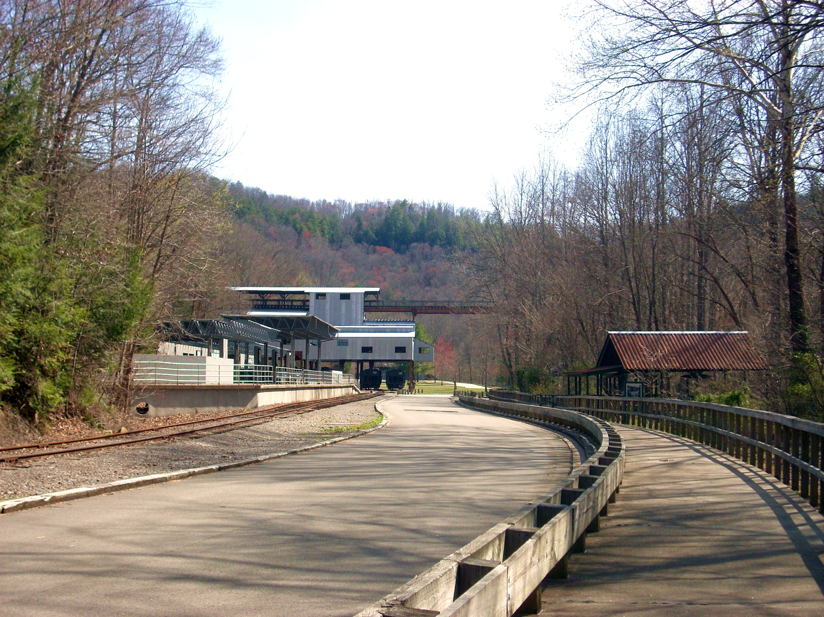
This must be my week for scenic railroads because when we arrived at Blue
Heron I saw another one! On Monday and Wednesday I’d passed
by a scenic railroad just
outside
Versailles on my way to accessing the Kentucky
River in Tyrone.
Well,
Blue Heron is apparently a stop on the
Big South Fork
Scenic Railway which
offers train rides in the area. Also interesting here are all the interactive exhibits
you'll find which represent the life and times of the old mining camp I
mentioned.
I got in my kayak and set off
before the other guys since I didn’t have as much gear. They
were doing an overnight trip back down to KY927 (roughly 24 miles or so) and,
oddly enough, I wouldn’t end up seeing either them or the other group of 30 for the
rest of the day. In fact, I’d see no one else – only the
people in cars driving over the 701 bridge at Yamacraw. In fact, I’d see or hear
absolutely no sign of civilization after this bridge. How
quiet was it? It was
so quiet that when I stopped
paddling I nearly fell asleep amid the tranquility!
As I got started, however, it
was immediately apparent that the water was going to be a little low today.
You’ll put in between 2 shoals on this trip and I just missed getting
stuck immediately - I was just skimming over the rocks for the first mile or so.
This first section (from Blue Heron to Yamacraw) is where you’ll see 4
bridges - or traces of bridges. The first of the these appears to connect with
railroad, and the tracks for
the train would be with me on the right bank for the first couple miles or so.
You’ll also see the only flat land of the day on the right bank as you start.
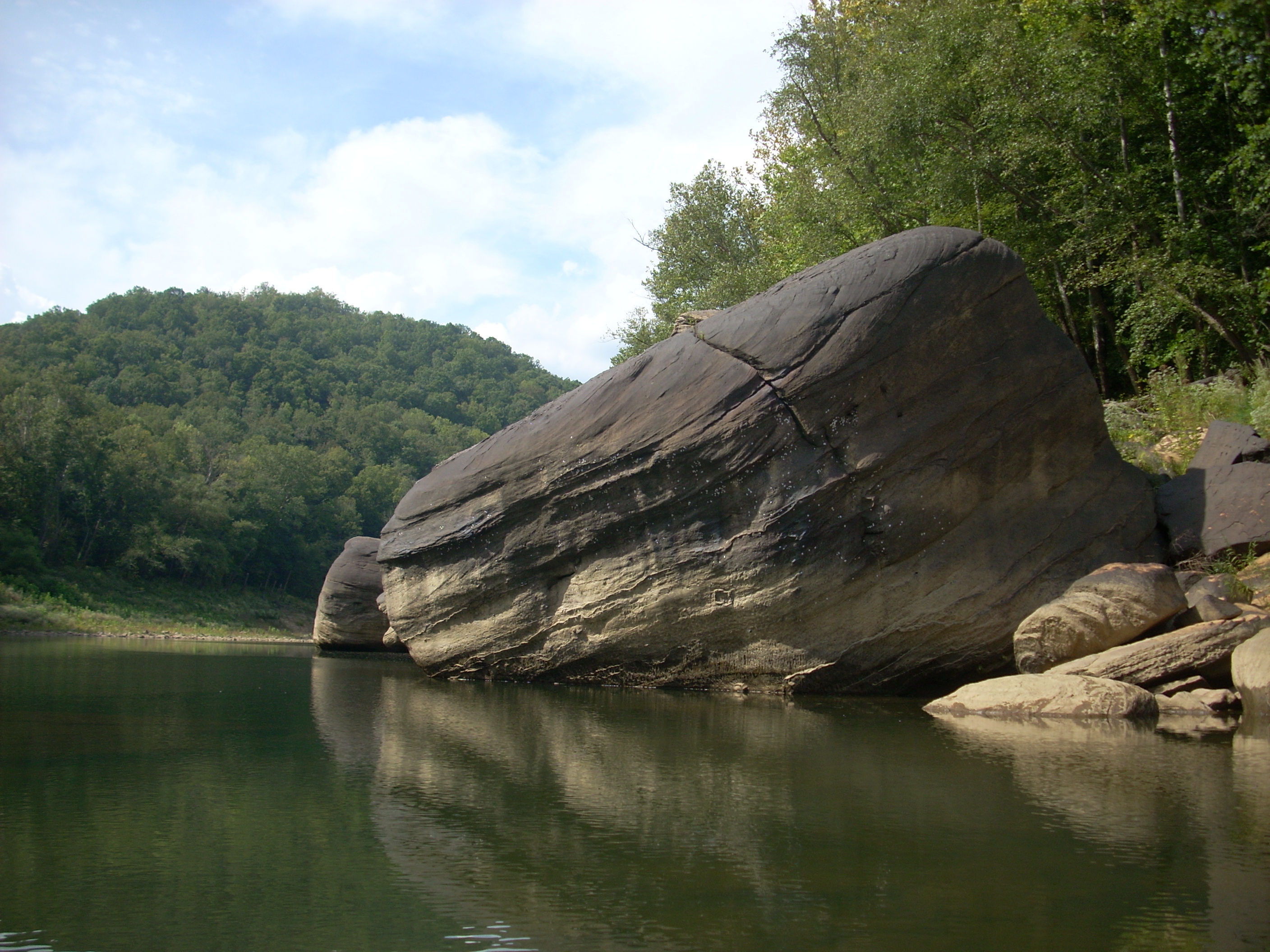
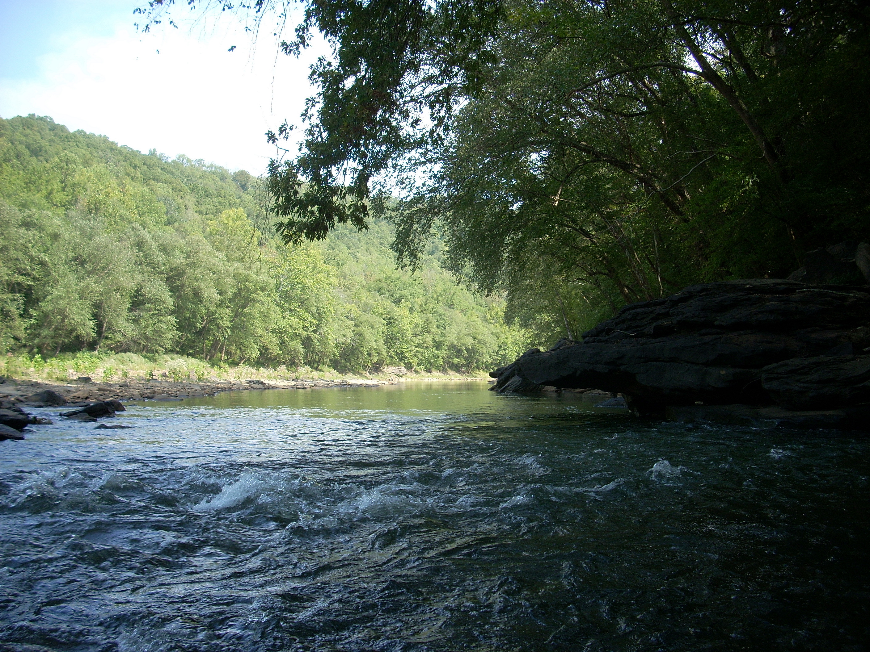
It also wouldn’t be long before the most significant feature of this
river became obvious: massive boulders along the banks.
There appeared to be many different kinds of these too. Some were
black, some brown; others tan, orange or white and there were many different
combinations of these colors as well. I thought the boulders really added to the
already outstanding views out here, and as I continued to paddle on I was met
with another incredible scene each time I rounded a corner.
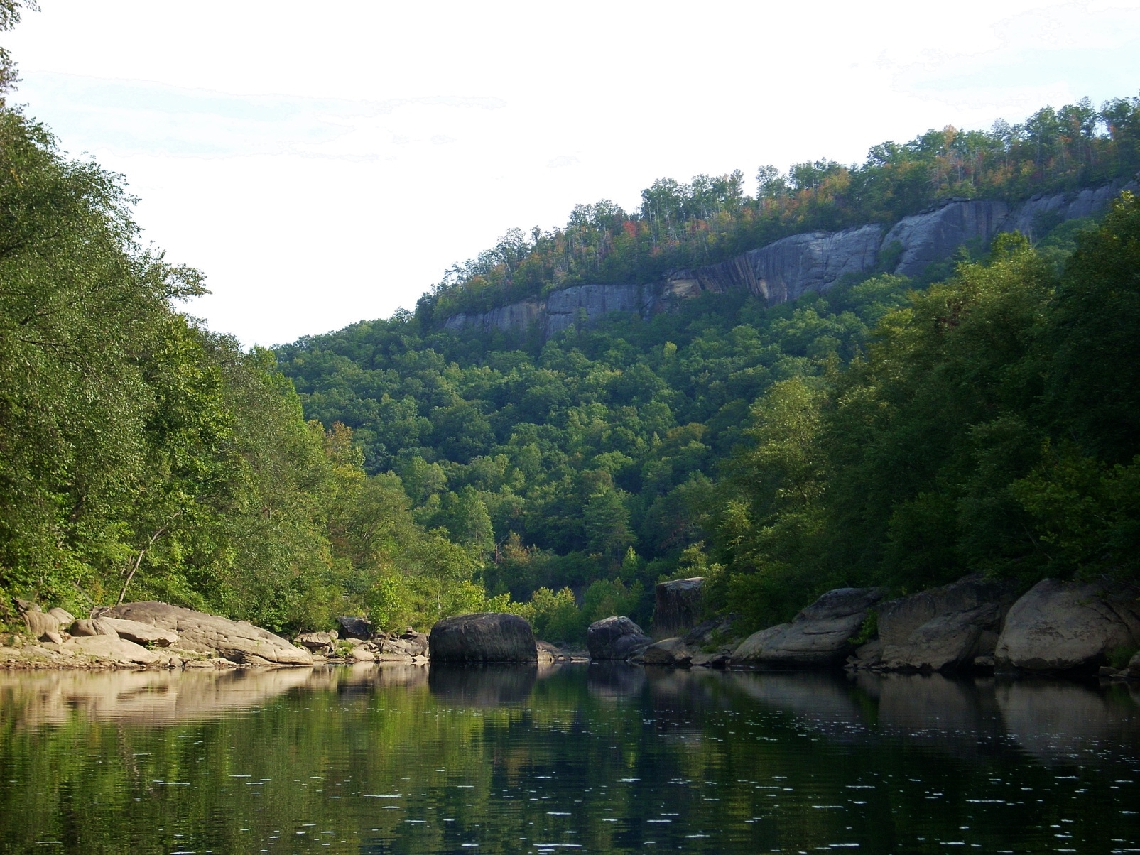
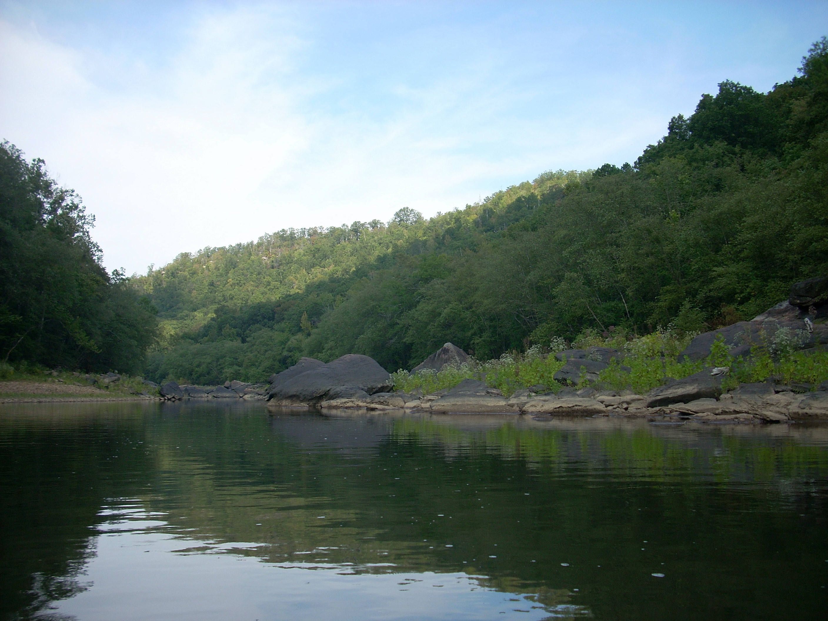
Another thing
about the rocks is that at times you’ll look down an alley of water and wonder
if you can actually make it around them. They seem to come
together in the distance, and if you didn’t know better you’d think that they
might actually stop your paddling adventure prematurely.
There will also be rock faces visible atop the hills in the distance too.
These
add to the visual effect - a shock and awe campaign for the senses!
Anyway, after
coming through the first “rock corridor” as I call them, there was quite an
interesting sight on the right. It was a little stream coming
in, but the water looked like it was running through a mound of orange clay.
The color was certainly appropriate! You are pretty close to
Tennessee here!

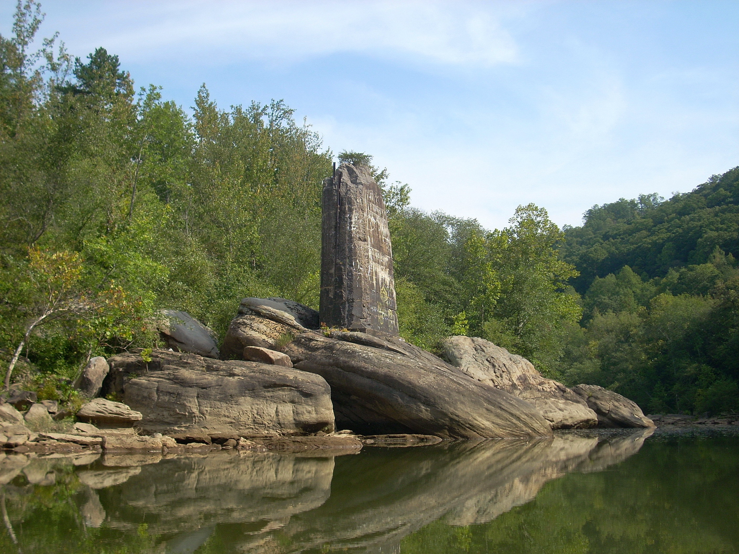
… and it was
soon after this that another interesting sight met my eye. There was
an incredibly old bridge column built onto one of the massive boulders on the
left side. This column had really crumbled over time and it
looked ancient, yet there it was, still standing! Another
rock I passed near this looked like a giant hamburger!
As I rounded yet another
corner I saw a third bridge that looked a lot like the one I'd seen at Yamacraw
when we dropped off the boats.
I didn’t think that could be possible because I didn't think I could have come
that far already. If so, I was a little disappointed that my trip was proceeding so
quickly, but it turned out to be a different bridge. This one was also
abandoned quite a while ago as there was quite a bit of vegetation on top of
it. There was also some kind of rock structure to the right
of it which might have been about as old as the bridge itself.
It was concreted on top, and I wasn’t quite sure if this might have been
some kind of little pier or something?
The bridge at
Yamacraw did become visible shortly and I met with the scene below.
I'd been here last year. Seeing the spot both then and now helped me put
the water level in perspective.
Last year the most challenging rapid had been here,
yet because of the low water today that rapid now looked fairly tame.
The rock, nevertheless, did still prove to be a bit of a challenge.
It hangs low over the water, you see, and in trying to keep from going
under it last year I had run right into it!
At any rate, this second
section of the trip (from Yamacraw down to my car at Alum Ford) was to have a lot more riffle areas. I’d end up having to get out at most of them.
At first I paddled through some, but there turned out to be so many that
I thought I might scratch up my boat a little too much if I continued. I
ported from then on. "El klutz-o" here slipped and fell the
first time escorting his boat through, however, and after that I held onto the
boat with both hands for support as I negotiated my way over the rocks!
I’d say that although this trip is beautiful any time you go, I think it best to
do in the spring or early summer when the water is higher.
Anyway, when I
did get to these riffles I decided to enjoy them even though they meant some
extra work.
I’ve mentioned before what I think about foiled plans. I
think foiled plans mean that the
Lord wants to show you something different, and today I think that
something might have been the gentle sounds that the riffles made.
I might not have enjoyed them as much if I’d been paddling down on faster
and higher water - I might have just kept going. This time,
however, I let the sounds soothe me as I took them in amid the beautiful scenery
and peaceful atmosphere here – and nearly fell asleep
as I did so!

There were some more
interesting rock formations in here too. There was one spot
where 2 rocks met on the right and they were kind of jammed together to form a
near perfect circle of erosion right between them.
In another spot
there was a wild turkey roaming the bank on the left, and I followed it for a
while as it meandered around the downed foliage. I hadn’t
seen as many of these birds on the
Kentucky River
this year
as opposed to last, so it was nice to spot one again.

There was one
really good point of moving water next which was fun and which nearly got me soaked.
On it there was a rock angling down so it got your boat to really slope
downwards. As it did, and you reach the end of this rock
slope, the water will come up over your boat in one big wave as you negotiate
it. This one was fun! I should mention
too, that on this section of the river there are plenty of shoals and other
places where you can stop and rest or even camp.
You’ll see the "boat ramp” for Alum
Ford after a last right curve. I use the term loosely
because I don’t think you’d want to bring a power boat down here!
Today the ramp had about a 2 foot drop-off to the water!
I completed my day by paddling just past this point to get a look around the last river curve and then, with my
car waiting at the top of the ramp for me like a faithful servant, I headed home for a good nights sleep!
DIRECTIONS:
To Alum Ford:
US27 to KY700. Go west until you can’t go west any
more!
Sheltowee Trace
Outfitters has directions to the other sites when you schedule your trip.