Brecksville Reservation
Outer Loop Via Parts of Multiple Trails
Friday, March 17, 2012
Cuyahoga Valley Scenic Railroad Website
I’m embarrassed to admit that
I lived only a few miles from this park for nearly 3 years and never even
explored it!
That was before I got into hiking, but what an opportunity I missed! This preserve is
a great resource and well worth your time to visit. There are trail
options for every taste and fitness level with only one drawback – a general
lack of solitude. You’ll never be far from civilization and
there are several road crossings on this hike, but if this doesn’t bother you
then you’re in luck!
This hike will give you a
nice overview of what the reservation has to offer as it takes you on parts of
many different trails on a long lollipop loop around the perimeter of the park.
You’ll start out from the old railroad depot at the Station Road Bridge
on part of the Buckeye Trail (one which loops around
the entire state). You’ll then meet up with a part of
the Salamander Loop, travel most of the Deer Lick Cave Loop, traverse good
portions of the short Wildflower and Prairie Loops and then explore about half
of the Hemlock Loop (I’d also have incorporated the Chippewa Creek Loop but it
was washed out today). You’ll finally return on the main
bridle trail back to your car.
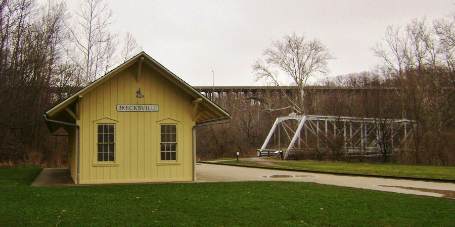
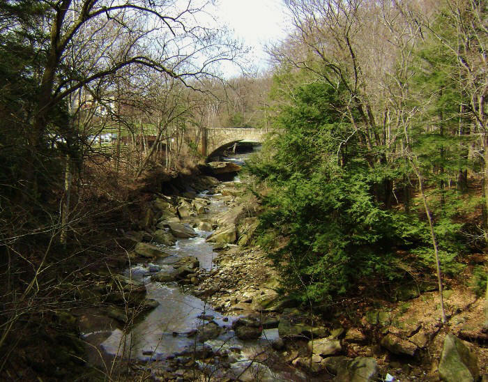
What a place this loop starts from! There’s an old railroad station (Brecksville Station) and a bridge (Station Road Bridge) that goes over the Cuyahoga River at the spot. Both make for really picturesque scenes. According to the placards placed here the station is not an original, but rather one built from similar specs. You could have fooled me. It sure looks original!
Meanwhile, the Cuyahoga Valley Scenic Railroad (see above website) runs from here and they offer many options if you want to take a step back in time and ride on the train. They even have special wine and beer tasting rides and Thomas the Train rides for the kids!
The Station Road Bridge,
however, is original. In fact, after being
used for more than 100 years it was eventually retired in 1992 but at that time
it was treated with what bordered on reverence. Apparently
disassembled, it was then shipped to New York, completely restored and then
returned and re-assembled right here upon the original spot!!!
Now that’s dedication! Incidentally, part of the 1400
mile Buckeye Trail actually goes over this bridge on its way up to Mentor
Headlands.
I started this hike by
walking back toward the reservation alongside the same road I’d just driven in
on (Chippewa Creek Raod). There’s a
bridle path that runs along the left side of the road while a multi-purpose
paved trail runs on the right. You can follow either. Both
will lead you to Riverview Road and you'll cross this road over the river
to reach a point on Chippewa Creek just
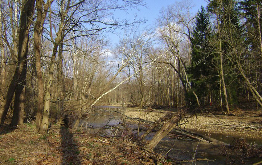
before it meets up with the Cuyahoga River. Follow the
blue-blazed path as it heads upstream alongside the Chippewa on the steams left
side.
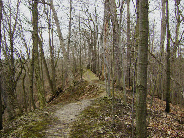
The path starts low but you’ll soon begin to break off to the left to begin a climb up through the pines. Ahead of you lies what they call the “My Mountain Scenic Overlook". A spur path will lead you to it after you’ve reached the top of the ridge. If you want to check it out just take the right. I found there to be some nice, although limited, vistas from here but I think I was even more taken with the character of the trail leading up to the overlook!
Upon your return to the main
trail you’ll continue to follow the blue blazes and at one point you’ll reach an
intersection. Take a left here. If you
turned right you’d be led back downhill to the road – which is OK if you’d like
a shorter hike.
The intersection afterwards
was a bit more confusing for me today. I didn’t see it on the
map. The blue blazes will have you making a right here but it
looks like if you took a left you’d be making a stroll along another ridge top.
I didn’t see any markings on this apparent spur trail so I guessed that
it might be one of those that’s been blazed by curious people. After
all, you’re generally apt to get some pretty nice views from ridge tops –
especially if you’ve got deep ravines on either side and the ridge top seems to
be coming to an end. That was the case here.
Anyway, the Salamander Loop
Trail intersection comes up next but this area was quite a bit boggy today and by
this time my socks were almost soaked clean through! I followed
this path a little way to get a feel for it and then came back. It’s a woodsy
stroll on a wide path.
Meanwhile, if you continue to
follow the blue blazes back on the Buckeye Trail you’ll soon cross a
multi-purpose trail and then a road – the Valley Parkway.
It’s on the other side of the parkway that you'll merge with the Deer Lick Cave
Trail and make a left to follow the road quite closely until you reach the namesake of the
new trail – the
Deer Lick Cave.
I should also
point out that there’s an interesting placard for the Buckeye Trail along this
stretch... Apparently founded in 1959, the Buckeye is – as
mentioned - a 1400 mile loop around the entire state but it’s not all
loop. In fact, according to this placard it looks as though
this very spot is one in which the trail actually splits – one direction heads
west to continue the loop while the other leads north up toward Mentor Headlands
to end on the shores of Lake Erie.
Anyway, the area around the cave was one of my favorite parts of the hike today as the area is quite remarkable. In fact, it reminded me a lot of my hikes in Kentucky with all the moss covered limestone there and I realize now how much I miss Kentucky. At the same time, I know there will be plenty of great things to see in Ohio too! Anyway, check these out! It’s really something to see!
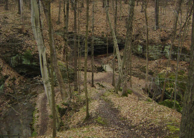
As you might be able to tell,
this was one very tough area to leave! I lingered for
quite a while, not wanting to tear myself away. When I
finally did I followed the path across another road – Meadows Drive in this case –
and it was here that I finally parted ways with the Buckeye Trail.
You’ll have been on it ever since the parking lot! It’ll
continue straight ahead while you’ll turn right to continue on the trail marked
by the brown leaf – the Deer Lick Cave Loop. In fact, this is
a combo Deer Lick/Bridle Trail at this point and you’re apt to see some horses –
as I did - but you’ll want to watch your step…
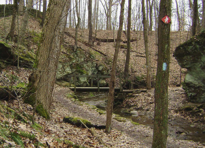
This section is pretty wide and it might have been an old road at one time. It’ll have you curving alongside a golf course before it dips into the first of two little ravines, at which point you’ll cross the streams which formed the ravines on a couple of nice wooden bridges. I liked how the road twisted its way through here…
Wait… Do
you ever have a song in your head that you can’t get rid of?
Hopefully it’s a good song and not one that drives you crazy, but I had Boys
Like Girls’ “Hero/Heroine” in my head all day today!
It’s a really good, catchy tune though! I’d sworn this band off for a time because their name struck me as being so darned
goofy but they finally broke me down. They’re quite good!
Anyway, cross another road
(Meadows Drive again) and then continue to follow the signs for the combination
Deer Lick/Bridle Path. As you do you'll take a left to follow the road for a short time before you
re-enter the woods to then curve down into and back out of another ravine.
You may see a trail break off to the right.
This is another section of the bridle trail according to the map. Keep
left.
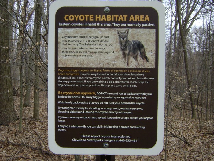
Meanwhile, there was a coyote sign along the road which was interesting. Apparently they’ve been spotted out here but they’re generally passive. The sign indicates that if one does approach the best thing to do is to walk away slowly while keeping the gaze of the animal. Then, if you keep yourself looking as large as possible it’s also supposed to help. Here’s the sign…
When you emerge on the far
side of the ravine you’ll be alongside a clearing and you may spot, as I did,
what looks like a little Christmas tree – complete with some ornaments! This
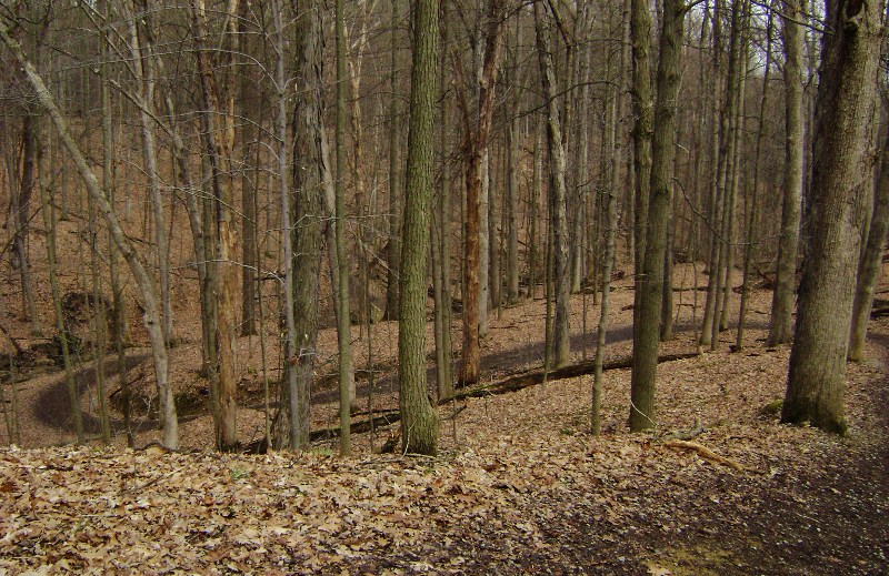
is all a nice contemplative stretch, simply a nice, pleasant,
woodsy stroll.
Dip down into yet another ravine now... This one actually looks like it’s been carved out by a few little streams. You’ll span 3 bridges before you come out…
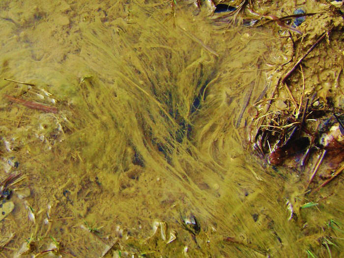
…and upon emerging you’ll be near the Meadows Picnic Area. You’ll probably want to be careful in here as the Bridle Path will cut off at a couple points - first to the left and then to the right. I’d continue to follow the brown leaf markings for the Deer Lick Cave Loop, but today when given a choice I thought that the second Bridle Trail turnoff looked more interesting. It led in an arc around a little field instead of going right through the picnic area, but in exploring this I only wound up doing was getting my feet even soggier. :) There were some interesting algae in this field, however…
Meanwhile, back at the Deer
Lick Loop things started to get a little confusing. You’ve
got about 4 different trails intertwining in here and I found that Deer Lick had
now merged with the Hemlock Loop, one marked to look like a blue Christmas tree!
I followed this combo for a very short time to the right and down a flight of
steps. That was it! At the bottom I took a
left to now travel along the Wildflower Loop Trail - and y’know what?
It took me right back up another flight of steps! The
Wildflower Loop Trail is a very short one (.75 mile) which is marked with what
looks like a flower – a powder puff blue flower.
Are these steps ever
interesting though! There are 3 flights of them that curve
down to converge in the middle where there seem to be about 10
trail markers! I continued to follow the Wildflower Loop
markers through the woods and soon reached the Harriett Keeler Memorial.
It comes up in the middle of a circle of pine trees and it's quite clear that
this woman was very well thought of!
Apparently a teacher and author, there are at least two
memorial markers dedicated to her memory here – one on a stone slab in the
middle of the circle, complete with a steel placard and another etched in a rock
on the north side of the circle. Also of interest on the eastern side of
the circle of pines is a cleared out, grassy area which is a Monarch Butterfly way-station!
Supposedly these beautiful creatures make a stop here as they journey from
Canada to the central mountains of Mexico!
Anyway, I basically
passed right through the middle of the circle to follow a combination Prairie
Loop Trail/Hemlock Loop Trail across the same road I came in on – Chippewa Road.
You're very close to the Route 82 park entrance at this point and you'll pass
the second Keeler memorial along with a couple interesting mill stones by the side of the
road.
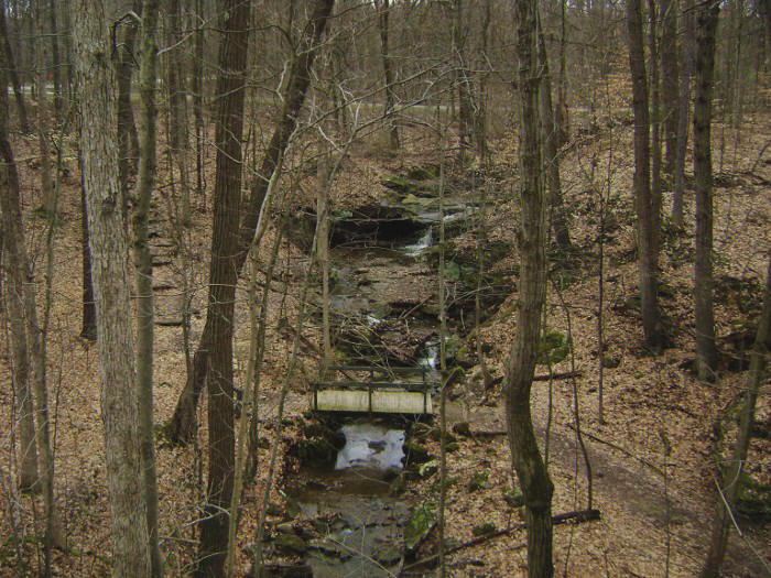
Cross the road now and follow the blue Christmas tree markings. You’ll make an immediate left onto the multi-purpose trail and then a near-immediate right to descend toward a nice rustic park shelter. Check out the views below! This is the Chippewa Creek Gorge scenic overlook, another spot that’s very hard to pull away from. As I was, you’re apt to really be captivated by the beauty of this scene.
Once you break away head to
the right. You’ll now be following the trail high above the
Chippewa Creek as it heads downstream. I found it interesting to remember
that I’d started out quite a while ago by following this creek upstream
from near the point where it emptied out into the Cuyahoga River.
You’ve just about come full circle. From here on
you’ll be travelling back toward that very spot – with the beautiful Chippewa
Creek as a companion!
Near the point where you’ll
see the – and let me clarify this – the Harriett Keeler Picnic Area (not
the memorial) the path will seem to split. Veer right.
I believe this is another spot where curious hikers might have sought
unmapped vistas, and in so doing tromped out a new trail.
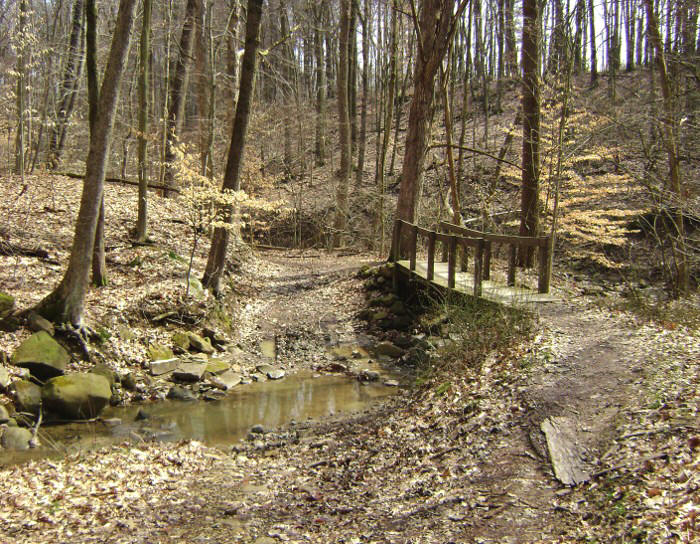
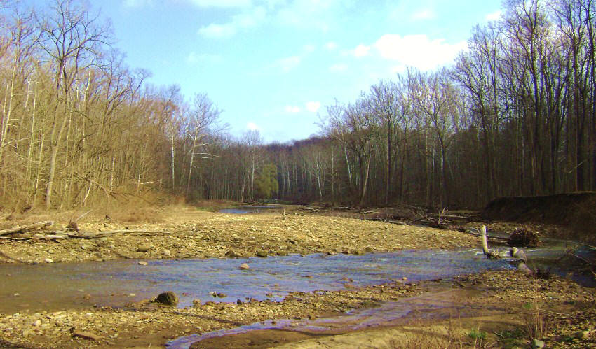
Soon you’ll begin to descend. You do want to thank the river for the beautiful vistas it’s been offering you - don’t you? (He asks with a smile.) At the bottom, after you cross a foot bridge, you’ll meet the Chippewa Creek Loop Trail. I headed to the left here intending to loop around on this but I soon discovered the trail to be washed out. I didn’t really fancy a swim/wade across so I backtracked to the spot where I’d started and continued on the Hemlock Loop Trail. This one will have you crossing a couple bridges, one of which is one of those interesting cable suspension bridges.
As you keep going you’ll soon
find yourself linking back up with the multi-purpose trail at a point near the
Chippewa Picnic Area. Here you could try to get a little too fancy
(as I did) or you can simply follow the multi-purpose path to the left and all
the way back to your car at the Station Road Bridge lot. That might be
better... My intention was to follow the Bridle Trail back
from here but I found it to merely be confusing.
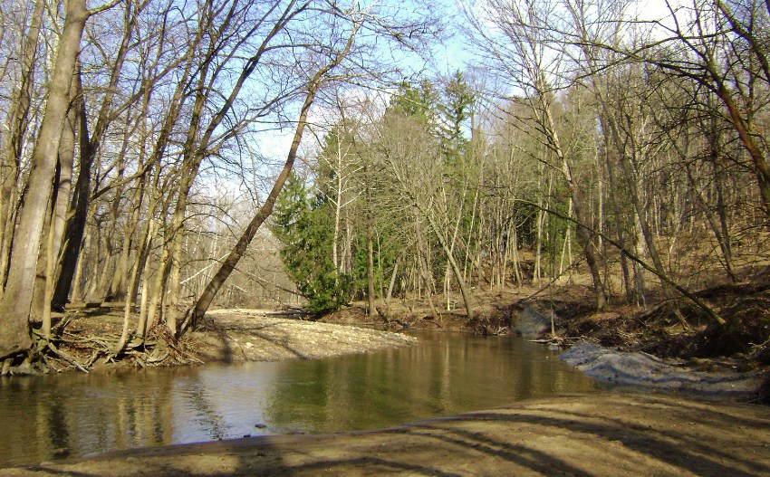
Either way, there’s a very pleasant spot on the multi-purpose trail where Chippewa Creek Road crosses the creek. I spotted some people enjoying the water here. It’s a great spot, and for the remainder of the hike today I spent my time paying respects to (and taking pictures of) the creek which had been such great company today!
DIRECTIONS:
Super easy. Just
take the Brecksville exit (Ohio Route 82) off of I77 south of Cleveland.
Head east, cross Ohio Route 21 in downtown Brecksville and go just past
the shopping center on the right. Brecksville Reservation is
the next right turn (Chippewa Creek Drive). Head straight and go
about 2 miles until the road dead-ends at the parking lot.
You’ll see the railroad depot. The trail starts on the paved
multi-purpose trail.